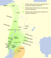
File:Mapa Tercera Dinastia de Ur.svg
From Wikimedia Commons, the free media repository
Jump to navigation
Jump to search

Size of this PNG preview of this SVG file: 350 × 400 pixels. Other resolutions: 210 × 240 pixels | 420 × 480 pixels | 672 × 768 pixels | 896 × 1,024 pixels | 1,792 × 2,048 pixels.
Original file (SVG file, nominally 350 × 400 pixels, file size: 326 KB)
File information
Structured data
Captions
Captions
Add a one-line explanation of what this file represents
Summary
[edit]| This SVG file contains embedded text that can be translated into your language, using any capable SVG editor, text editor or the SVG Translate tool. For more information see: About translating SVG files. |
This W3C-unspecified vector image was created with Inkscape .
| DescriptionMapa Tercera Dinastia de Ur.svg |
Español: Mapa de la extensión del imperio de la Tercera Dinastía de Ur en Mesopotamia y el Oriente Próximo asiático hacia los siglos XXII y XXI adC |
| Date | |
| Source |
Español: Trabajo propio, sobre este mapa; la información de la extensión ha sido obtenida de "Garelli, Paul: «El Imperio de Ur y su herencia», en El Próximo Oriente asiático. Barcelona: Labor 1974. ISBN 84-335-9310-2" |
| Author | Crates |
| Permission (Reusing this file) |
CC-BY-SA |
| Other versions | Derivative works of this file: Map of Ur III.svg |
Licensing
[edit]This file is licensed under the Creative Commons Attribution-Share Alike 3.0 Unported license.
- You are free:
- to share – to copy, distribute and transmit the work
- to remix – to adapt the work
- Under the following conditions:
- attribution – You must give appropriate credit, provide a link to the license, and indicate if changes were made. You may do so in any reasonable manner, but not in any way that suggests the licensor endorses you or your use.
- share alike – If you remix, transform, or build upon the material, you must distribute your contributions under the same or compatible license as the original.
File history
Click on a date/time to view the file as it appeared at that time.
| Date/Time | Thumbnail | Dimensions | User | Comment | |
|---|---|---|---|---|---|
| current | 21:16, 25 February 2008 |  | 350 × 400 (326 KB) | Phirosiberia (talk | contribs) | |
| 21:12, 25 February 2008 |  | 350 × 400 (326 KB) | Phirosiberia (talk | contribs) | ||
| 20:23, 25 February 2008 |  | 400 × 250 (333 KB) | Phirosiberia (talk | contribs) | ||
| 19:31, 25 February 2008 |  | 400 × 250 (340 KB) | Phirosiberia (talk | contribs) | {{inkscape}} {{Information |Description={{es|Mapa de la extensión del imperio de la Tercera Dinastía de Ur en Mesopotamia y el Oriente Próximo asiático hacia los siglos XXII y XXI adC}} |Source={{es|Trabajo propio, sobre [[Image:Ciudades del antiguo |
You cannot overwrite this file.
File usage on Commons
The following 4 pages use this file:
File usage on other wikis
The following other wikis use this file:
- Usage on ast.wikipedia.org
- Usage on ca.wikipedia.org
- Usage on es.wikipedia.org