File:Mapa Porto Santo pt.JPG
Jump to navigation
Jump to search
Size of this preview: 614 × 600 pixels. Other resolutions: 246 × 240 pixels | 492 × 480 pixels | 786 × 768 pixels | 1,109 × 1,083 pixels.
Original file (1,109 × 1,083 pixels, file size: 104 KB, MIME type: image/jpeg)
Captions
Captions
Add a one-line explanation of what this file represents
Summary
[edit]
| Description |
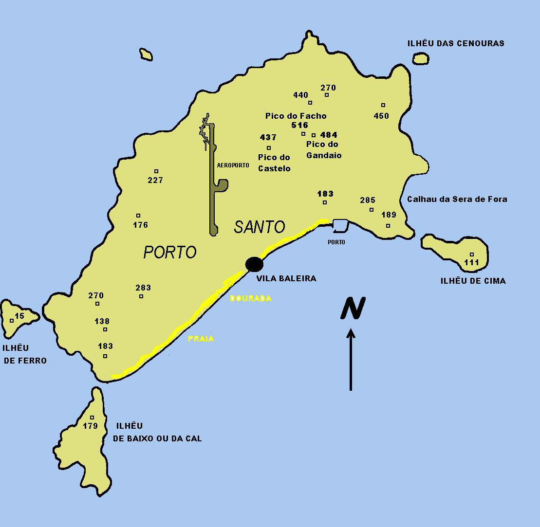
Čeština: Mapa ostrova Porto Santo. English: Map of Porto Santo island. Português: Mapa da ilha do Porto Santo. |
| Date | (UTC) |
| Source | |
| Author |
Original uploader was Zarco at cs.wikipedia
|
| This is a retouched picture, which means that it has been digitally altered from its original version. Modifications: tranlated. The original can be viewed here: Mapa Porto Santo.JPG:
|
Licensing
[edit]
I, the copyright holder of this work, hereby publish it under the following licenses:
| This file is licensed under the Creative Commons Attribution-Share Alike 3.0 Unported license. | ||
| ||
| This licensing tag was added to this file as part of the GFDL licensing update. |

|
Permission is granted to copy, distribute and/or modify this document under the terms of the GNU Free Documentation License, Version 1.2 or any later version published by the Free Software Foundation; with no Invariant Sections, no Front-Cover Texts, and no Back-Cover Texts. A copy of the license is included in the section entitled GNU Free Documentation License. |
You may select the license of your choice.
Original upload log
[edit]
This image is a derivative work of the following images:
- File:Mapa_Porto_Santo.JPG licensed with Cc-by-sa-3.0-migrated, GFDL
- 2010-10-25T03:08:33Z JotaCartas 1109x1083 (106236 Bytes) correct north; + translation
- 2010-10-25T00:42:25Z JotaCartas 1109x1083 (238596 Bytes) correct spelling (Ferro)
- 2009-03-27T12:49:47Z File Upload Bot (Magnus Manske) 1109x1083 (82836 Bytes) {{BotMoveToCommons|cs.wikipedia|year={{subst:CURRENTYEAR}}|month={{subst:CURRENTMONTHNAME}}|day={{subst:CURRENTDAY}}}} {{Information |Description={{cs|Mapa ostrova Porto Santo.}} |Source=Transferred from [http://cs.wikipedia
Uploaded with derivativeFX
File history
Click on a date/time to view the file as it appeared at that time.
| Date/Time | Thumbnail | Dimensions | User | Comment | |
|---|---|---|---|---|---|
| current | 03:24, 25 October 2010 | | 1,109 × 1,083 (104 KB) | JotaCartas (talk | contribs) | {{Information |Description={{cs|Mapa ostrova Porto Santo.}} {{en|Map of Porto Santo island.}} {{pt|Mapa da ilha do Porto Santo.}} |Source=*File:Mapa_Porto_Santo.JPG |Date=2010-10-25 03:23 (UTC) |Author=*File:Mapa_Porto_Santo.JPG: [[:cs:user:za |
You cannot overwrite this file.
File usage on Commons
The following 4 pages use this file:
File usage on other wikis
The following other wikis use this file:
- Usage on ar.wikipedia.org
- Usage on br.wikipedia.org
- Usage on de.wikipedia.org
- Usage on hu.wikipedia.org
- Usage on lb.wikipedia.org
- Usage on nl.wikipedia.org
- Usage on pl.wikipedia.org
- Usage on pt.wikipedia.org
- Usage on tt.wikipedia.org
- Usage on www.wikidata.org