File:Mapa Lit-Biełu 1919.svg
Jump to navigation
Jump to search

Size of this PNG preview of this SVG file: 745 × 600 pixels. Other resolutions: 298 × 240 pixels | 596 × 480 pixels | 954 × 768 pixels | 1,272 × 1,024 pixels | 2,545 × 2,048 pixels | 4,100 × 3,300 pixels.
Original file (SVG file, nominally 4,100 × 3,300 pixels, file size: 328 KB)
Captions
Captions
Add a one-line explanation of what this file represents
| Description |
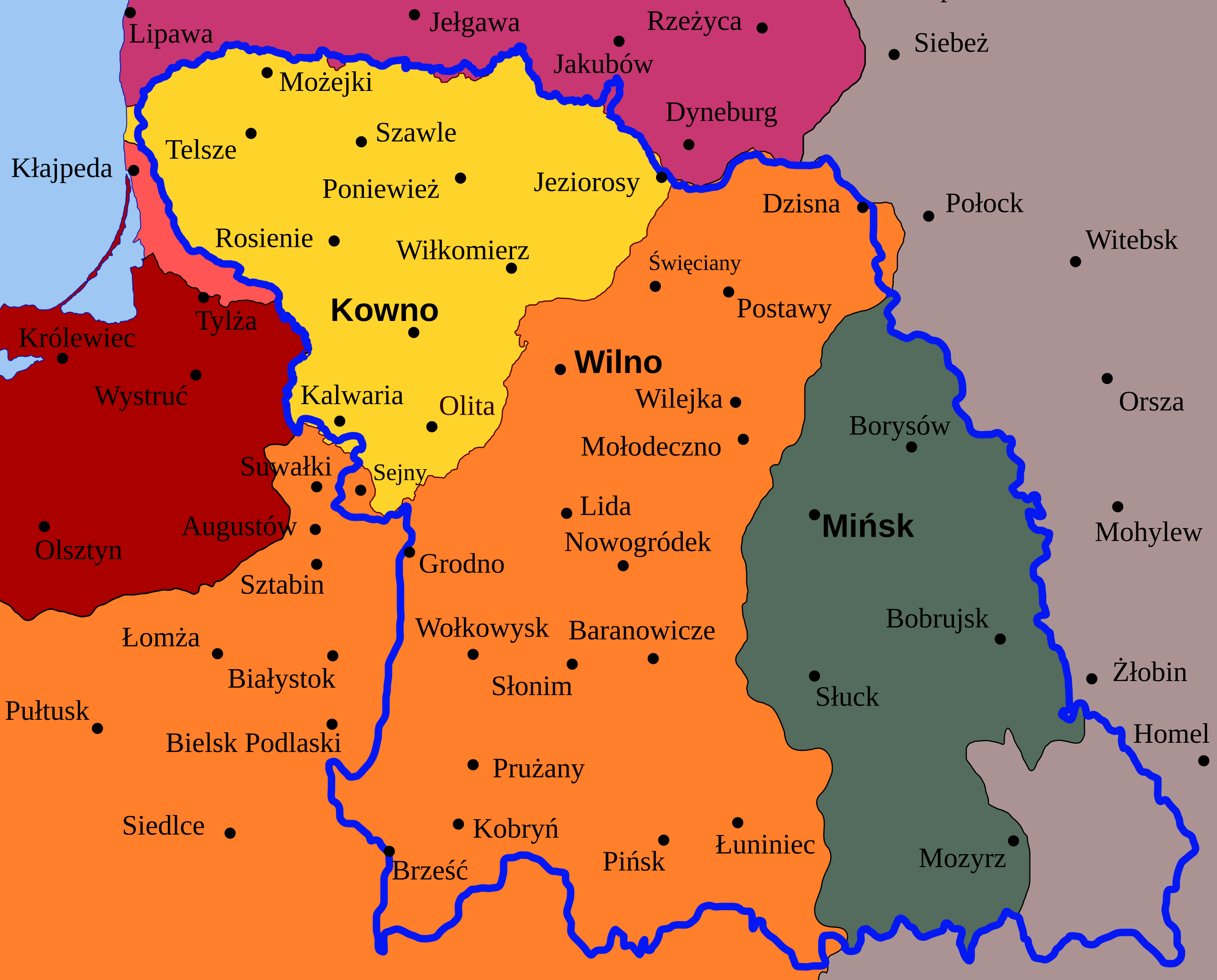
Map of planned border (thick blue line) for the en:Lithuanian–Belorussian Soviet Socialist Republic (commonly known as Litbel) superimposed on state borders in 1922. Germany
Latvia
Poland
Lithuania
Klaipėda Region (detached from Germany by the Treaty of Versailles)
Note: all cities have their current names, except for three cities in the Kaliningrad Oblast as their names were radically changed after the World War II. |
| Date | (UTC) |
| Source | |
| Author |
|
| Other versions |
|


I, the copyright holder of this work, hereby publish it under the following licenses:
This file is licensed under the Creative Commons Attribution-Share Alike 3.0 Unported license.
- You are free:
- to share – to copy, distribute and transmit the work
- to remix – to adapt the work
- Under the following conditions:
- attribution – You must give appropriate credit, provide a link to the license, and indicate if changes were made. You may do so in any reasonable manner, but not in any way that suggests the licensor endorses you or your use.
- share alike – If you remix, transform, or build upon the material, you must distribute your contributions under the same or compatible license as the original.

|
Permission is granted to copy, distribute and/or modify this document under the terms of the GNU Free Documentation License, Version 1.2 or any later version published by the Free Software Foundation; with no Invariant Sections, no Front-Cover Texts, and no Back-Cover Texts. A copy of the license is included in the section entitled GNU Free Documentation License. |
You may select the license of your choice.
Original upload log
[edit]
This image is a derivative work of the following images:
- File:Map_of_Litbel_1919.svg licensed with Cc-by-sa-3.0, GFDL
- 2010-08-20T19:02:26Z Bladyniec 4100x3300 (335583 Bytes) Ups, wrong proportions.
- 2010-08-20T18:54:04Z Bladyniec 6187x4240 (260072 Bytes) I've made some changes in city names. Names should be writted in version used that time. So: 1. No Olsztyn, Elbląg, Słupsk and Gdańsk. Changed into German names. 2. Cities in eastern Poland changed from Belarusian to Polis
- 2008-08-28T06:22:23Z Renata3 4100x3300 (321821 Bytes) blue line
- 2008-08-28T05:59:04Z Renata3 4100x3300 (321811 Bytes) fix
- 2008-08-28T05:58:02Z Renata3 4100x3300 (322342 Bytes) {{Information |Description= Map of planned border (thick green line) for [[:en:Lithuanian–Belorussian Soviet Socialist Republic]] (commonly known as Litbel) superimposed on European borders in 1920. |Source=Own work by uplo
Uploaded with derivativeFX
File history
Click on a date/time to view the file as it appeared at that time.
| Date/Time | Thumbnail | Dimensions | User | Comment | |
|---|---|---|---|---|---|
| current | 19:40, 20 August 2010 | | 4,100 × 3,300 (328 KB) | Tomasz Bladyniec (talk | contribs) | Small aesthetic changes |
| 19:34, 20 August 2010 |  | 4,100 × 3,300 (328 KB) | Tomasz Bladyniec (talk | contribs) | {{Information |Description=Map of planned border (thick blue line) for the en:Lithuanian–Belorussian Soviet Socialist Republic (commonly known as Litbel) superimposed on state borders in 1920. {{legend|#aa0000|Germany}} {{legend|#c83771|Latvia}} |
You cannot overwrite this file.
File usage on Commons
The following 2 pages use this file:
File usage on other wikis
The following other wikis use this file:
- Usage on pl.wikipedia.org