File:Mapa DK2.png
Jump to navigation
Jump to search

Size of this preview: 600 × 600 pixels. Other resolutions: 240 × 240 pixels | 480 × 480 pixels | 768 × 768 pixels | 1,024 × 1,024 pixels | 2,048 × 2,048 pixels | 3,690 × 3,690 pixels.
Original file (3,690 × 3,690 pixels, file size: 20.28 MB, MIME type: image/png)
Captions
Captions
Add a one-line explanation of what this file represents
| Description |
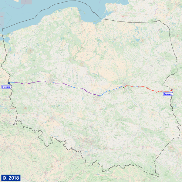
English: Map of Polish national road 2. Background from OpenStreetMap.
Expressway S2 (Southern Warsaw Bypass)
Motorway A2 (toll)
Motorway A2 (free) Polski: Mapa drogi krajowej nr 2. Tło mapy pochodzi z projektu OpenStreetMap.
Droga ekspresowa S2 (Południowa Obwodnica Warszawy)
Autostrada A2 (płatna)
Autostrada A2 (bezpłatna) |
| Date | |
| Source | Own work |
| Author | Miko101 |
| Other versions | File:PL-MapaDK2.svg (also my work) |
| Description |
This map was created from OpenStreetMap project data, collected by the community. This map may be incomplete, and may contain errors. Don't rely solely on it for navigation. |
|||
| Date | (see file history) | |||
| Source | openstreetmap.org | |||
| Creator |
OpenStreetMap contributors |
|||
| Permission (Reusing this file) |
OpenStreetMap data is available under the Open Database License (details). Map tiles are licensed under the Creative Commons Attribution-ShareAlike 2.0 license (CC-BY-SA 2.0).
This file is licensed under the Creative Commons Attribution-Share Alike 2.0 Generic license.
|
|||
| Georeferencing | If inappropriate please set warp_status = skip to hide. |
This file is licensed under the Creative Commons Attribution-Share Alike 2.0 Generic license.
- You are free:
- to share – to copy, distribute and transmit the work
- to remix – to adapt the work
- Under the following conditions:
- attribution – You must give appropriate credit, provide a link to the license, and indicate if changes were made. You may do so in any reasonable manner, but not in any way that suggests the licensor endorses you or your use.
- share alike – If you remix, transform, or build upon the material, you must distribute your contributions under the same or compatible license as the original.
File history
Click on a date/time to view the file as it appeared at that time.
| Date/Time | Thumbnail | Dimensions | User | Comment | |
|---|---|---|---|---|---|
| current | 10:41, 16 September 2018 | | 3,690 × 3,690 (20.28 MB) | Miko101 (talk | contribs) | odświeżenie mapy, ujednolicenie kolorów poszczególnych odcinków |
| 23:30, 27 July 2014 |  | 2,360 × 1,815 (6.56 MB) | Miko101 (talk | contribs) | wyróżnienie odcinków płatnych / toll sections | |
| 19:53, 22 July 2014 |  | 2,360 × 1,815 (6.56 MB) | Miko101 (talk | contribs) | odświeżenie mapy, aktualizacja | |
| 22:18, 18 August 2013 |  | 936 × 920 (801 KB) | Miko101 (talk | contribs) | S2 update | |
| 02:10, 6 January 2013 |  | 936 × 920 (797 KB) | Miko101 (talk | contribs) | {{GIMP}} {{Information |Description ={{en|1=Map of Polish national road 2. Background from OpenStreetMap. Green stretch is a part of Western Bypass of Warsar (with expressway S8).<br/> This map is in PNG format, because export a map from OSM with th... |
You cannot overwrite this file.
File usage on Commons
The following 3 pages use this file:
File usage on other wikis
The following other wikis use this file:
- Usage on en.wikipedia.org
- Usage on lv.wikipedia.org
- Usage on pl.wikipedia.org
- Usage on th.wikipedia.org
- Usage on www.wikidata.org