File:Mapa Carmen Herrera.PNG
Jump to navigation
Jump to search

Size of this preview: 800 × 541 pixels. Other resolutions: 320 × 216 pixels | 640 × 433 pixels | 929 × 628 pixels.
Original file (929 × 628 pixels, file size: 63 KB, MIME type: image/png)
Captions
Captions
Add a one-line explanation of what this file represents
Summary
[edit]
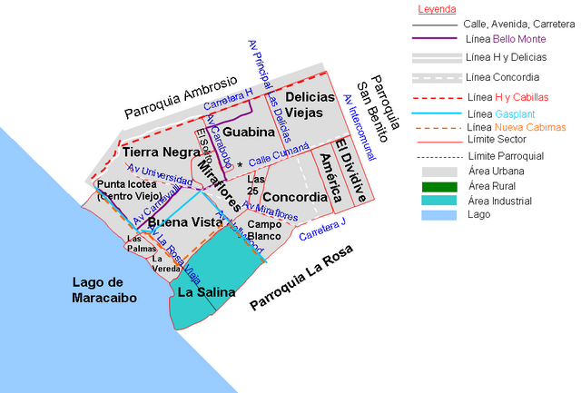
| Description | Mapa de la Parroquia Carmen Herrera, Municipio Cabimas, Zulia, Venezuela |
| Date | 01/07/2008 |
| Source | Own work |
| Author | Andrés González |
Licensing
[edit]
| I, the copyright holder of this work, release this work into the public domain. This applies worldwide. In some countries this may not be legally possible; if so: I grant anyone the right to use this work for any purpose, without any conditions, unless such conditions are required by law. |
File history
Click on a date/time to view the file as it appeared at that time.
| Date/Time | Thumbnail | Dimensions | User | Comment | |
|---|---|---|---|---|---|
| current | 20:43, 18 August 2010 | | 929 × 628 (63 KB) | Andrés González (talk | contribs) | Nuevo mapa con escala, norte y leyenda |
| 21:00, 1 July 2008 |  | 547 × 438 (32 KB) | Andrés González (talk | contribs) | {{Information |Description=Mapa de la Parroquia Carmen Herrera, Municipio Cabimas, Zulia, Venezuela |Source=Own work |Date=01/07/2008 |Author=Andrés González |Permission= |other_versions= }} {{ImageUpload|basic}} |
You cannot overwrite this file.
File usage on Commons
There are no pages that use this file.
File usage on other wikis
The following other wikis use this file:
- Usage on es.wikipedia.org
- Guavina
- Usuaria:Laura Fiorucci/Parroquia Carmen Herrera
- Delicias Viejas
- El Solito
- Buena Vista (Cabimas)
- Campo Blanco
- Tierra Negra (Cabimas)
- Miraflores (Cabimas)
- Las 25
- Concordia (Cabimas)
- El Dividive (Cabimas)
- Campo Staff
- Barrio La Vereda
- América Cabimas
- Las Tierritas
- Campo Refinería
- Centro Viejo (Cabimas)