File:Map spb 1737 high.jpg
Jump to navigation
Jump to search

Size of this preview: 800 × 487 pixels. Other resolutions: 320 × 195 pixels | 640 × 389 pixels | 1,024 × 623 pixels | 1,280 × 779 pixels | 2,400 × 1,460 pixels.
Original file (2,400 × 1,460 pixels, file size: 784 KB, MIME type: image/jpeg)
Captions
Captions
Add a one-line explanation of what this file represents
Summary
[edit]| Description |
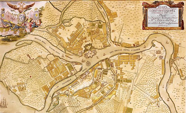
Русский: Карта Санкт-Петербурга. План Императорского столичного города Санкт-Петербурга, сочиненый в 1737 году. Один из первых городских планов, на котором изображены последствия пожара в Морской Слободе в 1736-1737 годах
English: Map of Saint Petersburg (Russia)
Français : Carte de Saint-Pétersbourg.
Español: Mapa de San Petersburgo.
Deutsch: Karte der Sankt Petersburg. Plan der Kayserl. Residentz Stadt St. Petersburg wie solcher A 1737 aufgenommen worden. |
| Date | |
| Source | http://www.spbin.ru/maps/map_anonym_1737.htm |
| Author | Петербургская Aкадемия наук |
| Other versions |
Derivative works of this file:
|
.jpg)
Licensing
[edit]
|
This work is in the public domain in its country of origin and other countries and areas where the copyright term is the author's life plus 100 years or fewer. | |
| This file has been identified as being free of known restrictions under copyright law, including all related and neighboring rights. | |
File history
Click on a date/time to view the file as it appeared at that time.
| Date/Time | Thumbnail | Dimensions | User | Comment | |
|---|---|---|---|---|---|
| current | 07:43, 25 May 2010 | | 2,400 × 1,460 (784 KB) | Peterburg23 (talk | contribs) | == Summary == {{Information |Description=Карта Санкт-Петербурга составленная в 1737 г. |Source=http://www.spbin.ru/maps/map_anonym_1737.htm |Date=1737 |Author=Неизвестен |Permission= |other_versions= }} == Licen |
You cannot overwrite this file.
File usage on Commons
The following 2 pages use this file: