File:Map showing countries President Samia Suluhu of Tanzania has visited.svg
Jump to navigation
Jump to search

Size of this PNG preview of this SVG file: 800 × 411 pixels. Other resolutions: 320 × 164 pixels | 640 × 329 pixels | 1,024 × 526 pixels | 1,280 × 657 pixels | 2,560 × 1,314 pixels | 863 × 443 pixels.
Original file (SVG file, nominally 863 × 443 pixels, file size: 1.55 MB)
Captions
Captions
Add a one-line explanation of what this file represents

Any autoconfirmed user can overwrite this file from the same source. Please ensure that overwrites comply with the guideline.

|
This file may be updated to reflect new information. If you wish to use a specific version of the file without it being overwritten, please upload the required version as a separate file. |
Summary
[edit]
| Description |
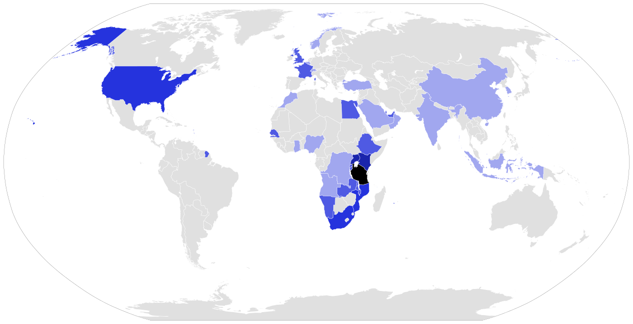
English: Map showing countries President Samia Suluhu of Tanzania has visited on official visits since assuming office in March 2021. |
| Date | |
| Source | Own work |
| Author | Sputink |
Licensing
[edit]
I, the copyright holder of this work, hereby publish it under the following license:
This file is licensed under the Creative Commons Attribution-Share Alike 4.0 International license.
- You are free:
- to share – to copy, distribute and transmit the work
- to remix – to adapt the work
- Under the following conditions:
- attribution – You must give appropriate credit, provide a link to the license, and indicate if changes were made. You may do so in any reasonable manner, but not in any way that suggests the licensor endorses you or your use.
- share alike – If you remix, transform, or build upon the material, you must distribute your contributions under the same or compatible license as the original.
File history
Click on a date/time to view the file as it appeared at that time.
| Date/Time | Thumbnail | Dimensions | User | Comment | |
|---|---|---|---|---|---|
| current | 14:31, 9 September 2024 | | 863 × 443 (1.55 MB) | Sputink (talk | contribs) | China FOCAC // Editing SVG source code using c:User:Rillke/SVGedit.js |
| 19:39, 1 September 2024 |  | 863 × 443 (1.55 MB) | Sputink (talk | contribs) | Kenya AU // Editing SVG source code using c:User:Rillke/SVGedit.js | |
| 02:17, 24 August 2024 |  | 863 × 443 (1.55 MB) | Sputink (talk | contribs) | Rw and ZW Aug24 // Editing SVG source code using c:User:Rillke/SVGedit.js | |
| 20:01, 21 June 2024 |  | 863 × 443 (1.55 MB) | Sputink (talk | contribs) | RSA and KR June 2024 // Editing SVG source code using c:User:Rillke/SVGedit.js | |
| 12:51, 18 May 2024 |  | 863 × 443 (1.55 MB) | Sputink (talk | contribs) | France 2024 // Editing SVG source code using c:User:Rillke/SVGedit.js | |
| 15:08, 3 May 2024 |  | 863 × 443 (1.55 MB) | Sputink (talk | contribs) | Fix code error // Editing SVG source code using c:User:Rillke/SVGedit.js | |
| 13:43, 30 April 2024 |  | 863 × 443 (1.55 MB) | Sputink (talk | contribs) | Kenya April 2024 // Editing SVG source code using c:User:Rillke/SVGedit.js | |
| 17:22, 19 April 2024 |  | 863 × 443 (1.55 MB) | Sputink (talk | contribs) | Trukey 2024 // Editing SVG source code using c:User:Rillke/SVGedit.js | |
| 19:42, 25 February 2024 |  | 863 × 443 (1.55 MB) | Sputink (talk | contribs) | Nam Feb2024 // Editing SVG source code using c:User:Rillke/SVGedit.js | |
| 00:15, 19 February 2024 |  | 863 × 443 (1.55 MB) | Sputink (talk | contribs) | Ethiopa AU Feb 2024 // Editing SVG source code using c:User:Rillke/SVGedit.js |
You cannot overwrite this file.
File usage on Commons
The following 59 pages use this file:
- User:Chumwa/OgreBot/Transport Maps/2022 April 11-20
- User:Chumwa/OgreBot/Transport Maps/2022 August 21-31
- User:Chumwa/OgreBot/Transport Maps/2022 December 11-20
- User:Chumwa/OgreBot/Transport Maps/2022 February 19-28
- User:Chumwa/OgreBot/Transport Maps/2022 June 11-20
- User:Chumwa/OgreBot/Transport Maps/2022 May 11-20
- User:Chumwa/OgreBot/Transport Maps/2022 May 21-31
- User:Chumwa/OgreBot/Transport Maps/2022 November 1-10
- User:Chumwa/OgreBot/Transport Maps/2022 November 11-20
- User:Chumwa/OgreBot/Transport Maps/2022 September 11-20
- User:Chumwa/OgreBot/Transport Maps/2022 September 21-30
- User:Chumwa/OgreBot/Transport Maps/2023 December 1-10
- User:Chumwa/OgreBot/Transport Maps/2023 February 1-9
- User:Chumwa/OgreBot/Transport Maps/2023 February 19-28
- User:Chumwa/OgreBot/Transport Maps/2023 January 21-31
- User:Chumwa/OgreBot/Transport Maps/2023 March 11-20
- User:Chumwa/OgreBot/Transport Maps/2023 May 1-10
- User:Chumwa/OgreBot/Transport Maps/2023 May 21-31
- User:Chumwa/OgreBot/Transport Maps/2023 November 1-10
- User:Chumwa/OgreBot/Transport Maps/2023 November 11-20
- User:Chumwa/OgreBot/Transport Maps/2023 October 1-10
- User:Chumwa/OgreBot/Transport Maps/2023 October 21-31
- User:Chumwa/OgreBot/Transport Maps/2023 September 1-10
- User:Chumwa/OgreBot/Transport Maps/2024 February 10-19
- User:Chumwa/OgreBot/Transport Maps/2024 February 20-29
- User:Chumwa/OgreBot/Transport Maps/2024 January 21-31
- User:Chumwa/OgreBot/Travel and communication maps/2022 April 11-20
- User:Chumwa/OgreBot/Travel and communication maps/2022 August 21-31
- User:Chumwa/OgreBot/Travel and communication maps/2022 December 11-20
- User:Chumwa/OgreBot/Travel and communication maps/2022 February 19-28
- User:Chumwa/OgreBot/Travel and communication maps/2022 June 11-20
- User:Chumwa/OgreBot/Travel and communication maps/2022 May 11-20
- User:Chumwa/OgreBot/Travel and communication maps/2022 May 21-31
- User:Chumwa/OgreBot/Travel and communication maps/2022 November 1-10
- User:Chumwa/OgreBot/Travel and communication maps/2022 November 11-20
- User:Chumwa/OgreBot/Travel and communication maps/2022 September 11-20
- User:Chumwa/OgreBot/Travel and communication maps/2022 September 21-30
- User:Chumwa/OgreBot/Travel and communication maps/2023 December 1-10
- User:Chumwa/OgreBot/Travel and communication maps/2023 February 1-9
- User:Chumwa/OgreBot/Travel and communication maps/2023 February 19-28
- User:Chumwa/OgreBot/Travel and communication maps/2023 January 21-31
- User:Chumwa/OgreBot/Travel and communication maps/2023 March 11-20
- User:Chumwa/OgreBot/Travel and communication maps/2023 May 1-10
- User:Chumwa/OgreBot/Travel and communication maps/2023 May 21-31
- User:Chumwa/OgreBot/Travel and communication maps/2023 November 1-10
- User:Chumwa/OgreBot/Travel and communication maps/2023 November 11-20
- User:Chumwa/OgreBot/Travel and communication maps/2023 October 1-10
- User:Chumwa/OgreBot/Travel and communication maps/2023 October 21-31
- User:Chumwa/OgreBot/Travel and communication maps/2023 September 1-10
- User:Chumwa/OgreBot/Travel and communication maps/2024 April 11-20
- User:Chumwa/OgreBot/Travel and communication maps/2024 April 21-30
- User:Chumwa/OgreBot/Travel and communication maps/2024 August 21-31
- User:Chumwa/OgreBot/Travel and communication maps/2024 February 10-19
- User:Chumwa/OgreBot/Travel and communication maps/2024 February 20-29
- User:Chumwa/OgreBot/Travel and communication maps/2024 January 21-31
- User:Chumwa/OgreBot/Travel and communication maps/2024 June 21-30
- User:Chumwa/OgreBot/Travel and communication maps/2024 May 1-10
- User:Chumwa/OgreBot/Travel and communication maps/2024 May 11-20
- User:Chumwa/OgreBot/Travel and communication maps/2024 September 1-10
File usage on other wikis
The following other wikis use this file:
- Usage on dag.wikipedia.org
- Usage on en.wikipedia.org
- Usage on ha.wikipedia.org
- Usage on sr.wikipedia.org