File:Map showing coast of Argentina from 44⁰05ʹS to 49⁰52ʹS - Union Point to Port San Julián. LOC 89696427.jpg
Jump to navigation
Jump to search

Size of this preview: 424 × 599 pixels. Other resolutions: 170 × 240 pixels | 340 × 480 pixels | 543 × 768 pixels | 725 × 1,024 pixels | 1,449 × 2,048 pixels | 4,494 × 6,350 pixels.
Original file (4,494 × 6,350 pixels, file size: 2.54 MB, MIME type: image/jpeg)
Captions
Captions
Add a one-line explanation of what this file represents
Summary
[edit]| Description |
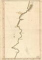
English: Oriented with north to the bottom. Black and brown inks and watercolor. Mounted on cloth backing. LC Luso-Hispanic World, 138 Available also through the Library of Congress Web site as a raster image. Maggs number annotated in pencil in upper right corner: 289. Vault |
||
| Title | [Map showing coast of Argentina from 44⁰05ʹS to 49⁰52ʹS : Union Point to Port San Julián]. | ||
| Shelf ID | G5352.C6 17-- .M3 | ||
| Date | |||
| Source | https://www.loc.gov/item/89696427/ | ||
| Author | Unknown author | ||
| Permission (Reusing this file) |
|
||
| Other versions |
|
||
| Location | Argentina | ||
| Part of | American Memory · Catalog · Geography And Map Division · Cultural Landscapes | ||
| Subject | Maps, Manuscript · Argentina · Coasts · Early Works To 1800 |

Licensing
[edit]
|
This is a faithful photographic reproduction of a two-dimensional, public domain work of art. The work of art itself is in the public domain for the following reason:
The official position taken by the Wikimedia Foundation is that "faithful reproductions of two-dimensional public domain works of art are public domain".
This photographic reproduction is therefore also considered to be in the public domain in the United States. In other jurisdictions, re-use of this content may be restricted; see Reuse of PD-Art photographs for details. | ||||
File history
Click on a date/time to view the file as it appeared at that time.
| Date/Time | Thumbnail | Dimensions | User | Comment | |
|---|---|---|---|---|---|
| current | 05:00, 26 May 2018 | | 4,494 × 6,350 (2.54 MB) | Fæ (talk | contribs) | LOC Maps https://www.loc.gov/item/89696427/ #1565 |
You cannot overwrite this file.
File usage on Commons
The following 3 pages use this file:
._LOC_89696427.jpg&redirect=no)