File:Map provinces Netherlands-nl.svg
Jump to navigation
Jump to search

Size of this PNG preview of this SVG file: 506 × 600 pixels. Other resolutions: 202 × 240 pixels | 405 × 480 pixels | 648 × 768 pixels | 864 × 1,024 pixels | 1,727 × 2,048 pixels | 743 × 881 pixels.
Original file (SVG file, nominally 743 × 881 pixels, file size: 856 KB)
Captions
Captions
Add a one-line explanation of what this file represents
This W3C-unspecified vector image was created with Inkscape .

|
This SVG file contains embedded text that can be translated into your language, using any capable SVG editor, text editor or the SVG Translate tool. For more information see: About translating SVG files. |
Summary[edit]
| Description |
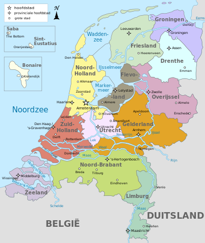
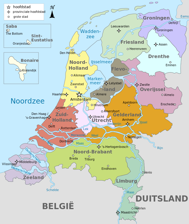
Français : Carte des provinces de Pays-Bas en néerlandais
English: Map of the provinces of the Netherlands in Dutch |
| Date | |
| Source | Own work. Translated from File:Map provinces Netherlands-de.svg, using this map for the Dutch names |
| Author | Alphathon (original German SVG); Bibi Saint-Pol (SVG translation) |
| Other versions |
[]
|


.svg)
Licensing[edit]
I, the copyright holder of this work, hereby publish it under the following licenses:
This file is licensed under the Creative Commons Attribution-Share Alike 3.0 Unported license.
- You are free:
- to share – to copy, distribute and transmit the work
- to remix – to adapt the work
- Under the following conditions:
- attribution – You must give appropriate credit, provide a link to the license, and indicate if changes were made. You may do so in any reasonable manner, but not in any way that suggests the licensor endorses you or your use.
- share alike – If you remix, transform, or build upon the material, you must distribute your contributions under the same or compatible license as the original.

|
Permission is granted to copy, distribute and/or modify this document under the terms of the GNU Free Documentation License, Version 1.2 or any later version published by the Free Software Foundation; with no Invariant Sections, no Front-Cover Texts, and no Back-Cover Texts. A copy of the license is included in the section entitled GNU Free Documentation License. |
You may select the license of your choice.
File history
Click on a date/time to view the file as it appeared at that time.
| Date/Time | Thumbnail | Dimensions | User | Comment | |
|---|---|---|---|---|---|
| current | 22:43, 18 April 2023 | | 743 × 881 (856 KB) | Von Freudstein-Reinach (talk | contribs) | File uploaded using svgtranslate tool (https://svgtranslate.toolforge.org/). Added translation for oc. |
| 11:43, 17 February 2019 |  | 743 × 881 (809 KB) | Thayts (talk | contribs) | Fixed Eastern Scheldt which wasn't rendered by the MediaWiki engine; removed Belgian city of Antwerp | |
| 13:29, 16 February 2019 |  | 743 × 881 (809 KB) | Thayts (talk | contribs) | Updated borders | |
| 08:53, 15 October 2014 |  | 743 × 881 (887 KB) | Bibi Saint-Pol (talk | contribs) | User created page with UploadWizard |
You cannot overwrite this file.
File usage on Commons
The following 17 pages use this file:
- Atlas of the Netherlands
- User:Magog the Ogre/Multilingual legend/2023 April 11-20
- File:Map provinces Netherlands-de.svg
- File:Map provinces Netherlands-el.svg
- File:Map provinces Netherlands-en.svg
- File:Map provinces Netherlands-es.svg
- File:Map provinces Netherlands-fr.svg
- File:Map provinces Netherlands-fy.svg
- File:Map provinces Netherlands-he.svg
- File:Map provinces Netherlands-it.svg
- File:Map provinces Netherlands-ja.svg
- File:Map provinces Netherlands-mk.svg
- File:Map provinces Netherlands-nl.svg
- File:Netherlands Map (Without Islands).svg
- File:Netherlands map large dutch-10-10-10.png
- File:Netherlands map large dutch 3.png
- Template:Other versions/Map provinces Netherlands
File usage on other wikis
The following other wikis use this file:
- Usage on ar.wikipedia.org
- Usage on ban.wikipedia.org
- Usage on da.wikipedia.org
- Usage on en.wikipedia.org
- Usage on id.wikipedia.org
- Usage on ku.wikipedia.org
- Usage on li.wikipedia.org
- Usage on lld.wikipedia.org
- Usage on nds-nl.wikipedia.org
- Usage on nl.wikipedia.org
- Usage on uz.wikipedia.org
- Usage on vls.wikipedia.org
- Usage on vo.wikipedia.org
- Usage on zea.wikipedia.org
- Usage on zh.wikipedia.org