File:Map provinces Netherlands-he.svg
Jump to navigation
Jump to search

Size of this PNG preview of this SVG file: 506 × 600 pixels. Other resolutions: 202 × 240 pixels | 405 × 480 pixels | 648 × 768 pixels | 864 × 1,024 pixels | 1,727 × 2,048 pixels | 743 × 881 pixels.
Original file (SVG file, nominally 743 × 881 pixels, file size: 847 KB)
Captions
Captions
Add a one-line explanation of what this file represents
This W3C-unspecified vector image was created with Inkscape .

|
This SVG file contains embedded text that can be translated into your language, using any capable SVG editor, text editor or the SVG Translate tool. For more information see: About translating SVG files. |
Summary
[edit]| Description |
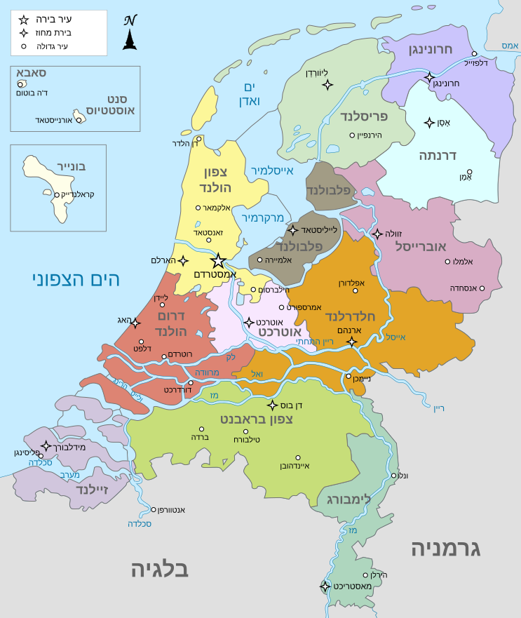
English: Map of The Netherlands (including the special municipalities of Saba, Saint Eustatius and Bonaire; the Caribbean Netherlands), showing provinces, large cities, rivers and lakes. English version
Deutsch: Karte der Niederlande, mit den Provinzen, der Karibischen Niederlande, den Großstädten und den Flüssen und Seen. Englische Version |
| Date | |
| Source |
This file was derived from: Map provinces Netherlands-en.svg |
| Author |
|
| Other versions |
[]
|


.svg)
| This is a retouched picture, which means that it has been digitally altered from its original version. Modifications: Translate to Hebrew. The original can be viewed here: Map provinces Netherlands-en.svg:
|
Licensing
[edit]
This file is licensed under the Creative Commons Attribution-Share Alike 3.0 Unported license.
- You are free:
- to share – to copy, distribute and transmit the work
- to remix – to adapt the work
- Under the following conditions:
- attribution – You must give appropriate credit, provide a link to the license, and indicate if changes were made. You may do so in any reasonable manner, but not in any way that suggests the licensor endorses you or your use.
- share alike – If you remix, transform, or build upon the material, you must distribute your contributions under the same or compatible license as the original.
File history
Click on a date/time to view the file as it appeared at that time.
| Date/Time | Thumbnail | Dimensions | User | Comment | |
|---|---|---|---|---|---|
| current | 08:26, 3 July 2016 | | 743 × 881 (847 KB) | Geagea (talk | contribs) | Editing SVG source code using User:Rillke/SVGedit.js; upload handled by User:Rillke/MwJSBot.js |
| 00:57, 3 July 2016 |  | 743 × 881 (847 KB) | Geagea (talk | contribs) | Editing SVG source code using User:Rillke/SVGedit.js; upload handled by User:Rillke/MwJSBot.js | |
| 00:24, 3 July 2016 |  | 743 × 881 (847 KB) | Geagea (talk | contribs) | Editing SVG source code using User:Rillke/SVGedit.js; upload handled by User:Rillke/MwJSBot.js | |
| 00:23, 3 July 2016 | No thumbnail | 0 × 0 (80 bytes) | Geagea (talk | contribs) | {{Inkscape}} {{translation possible}} == {{int:filedesc}} == {{Information |Description= {{en|Map of The Netherlands (including the special municipalities of Saba, Saint Eustatius and Bonaire; the Caribbean Netherlands), showing provinces, large cities... |
You cannot overwrite this file.
File usage on Commons
The following 14 pages use this file:
- User:Geagea/Israel/2016 July 3
- File:Map provinces Netherlands-de.svg
- File:Map provinces Netherlands-el.svg
- File:Map provinces Netherlands-en.svg
- File:Map provinces Netherlands-es.svg
- File:Map provinces Netherlands-fr.svg
- File:Map provinces Netherlands-fy.svg
- File:Map provinces Netherlands-he.svg
- File:Map provinces Netherlands-it.svg
- File:Map provinces Netherlands-ja.svg
- File:Map provinces Netherlands-mk.svg
- File:Map provinces Netherlands-nl.svg
- File:Netherlands Map (Without Islands).svg
- Template:Other versions/Map provinces Netherlands
File usage on other wikis
The following other wikis use this file:
- Usage on he.wikipedia.org