File:Map of the village of Bucksport, Hancock County, Maine LOC 2007626396.jpg
Jump to navigation
Jump to search

Size of this preview: 692 × 599 pixels. Other resolutions: 277 × 240 pixels | 554 × 480 pixels | 887 × 768 pixels | 1,182 × 1,024 pixels | 2,364 × 2,048 pixels | 11,664 × 10,104 pixels.
Original file (11,664 × 10,104 pixels, file size: 10.34 MB, MIME type: image/jpeg)
Captions
Captions
Add a one-line explanation of what this file represents
Summary
[edit]| Warning | The original file is very high-resolution. It might not load properly or could cause your browser to freeze when opened at full size. |
|---|
| Description |
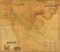
English: Cadastral map showing lot lines and names of landowners. Includes business directory and ill. Available also through the Library of Congress Web site as a raster image. Copy imperfect: Brittle, stained, creased, torn, missing small pieces, varnished, backed by cloth, cut into 2 sections. Acquisitions control no.: 2005-121 |
||
| Title | Map of the village of Bucksport, Hancock County, Maine | ||
| Shelf ID | G3734.B93G46 1875 .E2 | ||
| Date | |||
| Source | https://www.loc.gov/item/2007626396/ | ||
| Author | E.F. Sanford & C.T. Leggett; Bourquin, F. (Frederick); Worley & Bracher | ||
| Permission (Reusing this file) |
|
||
| Other versions |
|
||
| Location | United States · Bucksport · Maine | ||
| Part of | American Memory · Catalog · County Landownership Maps · Geography And Map Division · Cultural Landscapes | ||
| Subject | Bucksport · Landowners · United States · Maps · Real Property · Maine |

Licensing
[edit]
|
This is a faithful photographic reproduction of a two-dimensional, public domain work of art. The work of art itself is in the public domain for the following reason:
The official position taken by the Wikimedia Foundation is that "faithful reproductions of two-dimensional public domain works of art are public domain".
This photographic reproduction is therefore also considered to be in the public domain in the United States. In other jurisdictions, re-use of this content may be restricted; see Reuse of PD-Art photographs for details. | ||||
File history
Click on a date/time to view the file as it appeared at that time.
| Date/Time | Thumbnail | Dimensions | User | Comment | |
|---|---|---|---|---|---|
| current | 06:58, 24 May 2019 | | 11,664 × 10,104 (10.34 MB) | Fæ (talk | contribs) | LOC Maps https://www.loc.gov/item/2007626396/ #7801 |
You cannot overwrite this file.
File usage on Commons
The following page uses this file: