File:Map of the flooding areas of the Lake Nasser in the Wadi Halfa Salient.png
Jump to navigation
Jump to search

Size of this preview: 571 × 600 pixels. Other resolutions: 228 × 240 pixels | 457 × 480 pixels | 909 × 955 pixels.
Original file (909 × 955 pixels, file size: 1.25 MB, MIME type: image/png)
Captions
Captions
Add a one-line explanation of what this file represents
| Description |
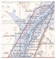
Deutsch: Überflutungsgebiet des Nasser-Stausees im Wadi Halfa Salient
English: Flooding areas of the Lake Nasser in the Wadi Halfa Salient |
||||||
| Date | see file history | ||||||
| Source |
own work, using the following files:
|
||||||
| Author | Maximilian Dörrbecker (Chumwa) | ||||||
| Permission (Reusing this file) |
I, the copyright holder of this work, hereby publish it under the following license: This file is licensed under the Creative Commons Attribution-Share Alike 2.5 Generic license.
|
||||||
| Other versions |
|


File history
Click on a date/time to view the file as it appeared at that time.
| Date/Time | Thumbnail | Dimensions | User | Comment | |
|---|---|---|---|---|---|
| current | 06:25, 20 June 2009 | | 909 × 955 (1.25 MB) | Chumwa (talk | contribs) | {{Information |Description={{de|Überflutungsgebiet des Nasser-Stausees im Wadi Halfa Salient}} {{en|Flooding areas of the Lake Nasser in the Wadi Halfa Salient}} |Source=own work, using the following files: * [[:File:Wadi Halfa Salient-txu-oclc-6949452- |
You cannot overwrite this file.
File usage on Commons
The following 3 pages use this file:
File usage on other wikis
The following other wikis use this file:
- Usage on ar.wikipedia.org
- Usage on bg.wikipedia.org
- Usage on ca.wikipedia.org
- Usage on de.wikipedia.org
- Usage on el.wikipedia.org
- Usage on en.wikipedia.org
- Usage on fr.wikipedia.org
- Usage on id.wikipedia.org
- Usage on it.wikipedia.org
- Usage on ja.wikipedia.org
- Usage on nl.wikipedia.org