File:Map of the country between Monterey, Tenn- & Corinth, Miss- showing the lines of entrenchments made & the routes followed by the U.S. forces under the command of Maj. Genl. Halleck, U.S. Army, in LOC 2008621634.jpg
Jump to navigation
Jump to search

Size of this preview: 480 × 600 pixels. Other resolutions: 192 × 240 pixels | 384 × 480 pixels | 615 × 768 pixels | 820 × 1,024 pixels | 1,640 × 2,048 pixels | 7,838 × 9,790 pixels.
Original file (7,838 × 9,790 pixels, file size: 8.08 MB, MIME type: image/jpeg)
Captions
Captions
Add a one-line explanation of what this file represents
Summary
[edit]| Description |
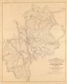
English: Relief shown by hachures. Includes houses, names of residents, fences, roads, railroads, vegetation, fields, and drainage. Differs from G3984.C8S5 1862 .M3 CW 267: lacks address of lithographer. Description derived from published bibliography. LC Civil War maps (2nd ed.), 267.1 Available also through the Library of Congress Web site as a raster image. |
||
| Title | Map of the country between Monterey, Tenn: & Corinth, Miss: showing the lines of entrenchments made & the routes followed by the U.S. forces under the command of Maj. Genl. Halleck, U.S. Army, in their advance upon Corinth in May 1862: | ||
| Shelf ID | G3984.C8S5 1862 .M32 | ||
| Date | |||
| Source | https://www.loc.gov/item/2008621634/ | ||
| Author | Matz, Otto H. | ||
| Permission (Reusing this file) |
|
||
| Other versions |
|
||
| Location | United States · Mississippi · Corinth | ||
| Part of | Military Battles And Campaigns · American Memory · Civil War Maps · Catalog · Geography And Map Division | ||
| Subject | Mississippi · Corinth, Battle Of, Corinth, Miss. · Corinth · United States · Maps · Corinth (Miss.), Battle Of |

Licensing
[edit]
|
This is a faithful photographic reproduction of a two-dimensional, public domain work of art. The work of art itself is in the public domain for the following reason:
The official position taken by the Wikimedia Foundation is that "faithful reproductions of two-dimensional public domain works of art are public domain".
This photographic reproduction is therefore also considered to be in the public domain in the United States. In other jurisdictions, re-use of this content may be restricted; see Reuse of PD-Art photographs for details. | ||||
File history
Click on a date/time to view the file as it appeared at that time.
| Date/Time | Thumbnail | Dimensions | User | Comment | |
|---|---|---|---|---|---|
| current | 16:28, 7 October 2018 | | 7,838 × 9,790 (8.08 MB) | Fæ (talk | contribs) | LOC Maps https://www.loc.gov/item/2008621634/ #251 |
You cannot overwrite this file.
File usage on Commons
The following page uses this file: