File:Map of the battlefield of Perryville, Ky - Major General Don Carlos Buell commanding the U.S. forces, General Braxton Bragg commanding the Confederate forces. October 8th 1862 LOC lva0000214.jpg
Jump to navigation
Jump to search

Size of this preview: 687 × 600 pixels. Other resolutions: 275 × 240 pixels | 550 × 480 pixels | 880 × 768 pixels | 1,173 × 1,024 pixels | 2,346 × 2,048 pixels | 4,630 × 4,042 pixels.
Original file (4,630 × 4,042 pixels, file size: 3.04 MB, MIME type: image/jpeg)
Captions
Captions
Add a one-line explanation of what this file represents
Summary
[edit]| Description |
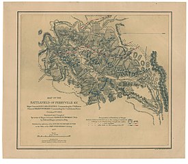
English: "Authorities: surveys by Edward Ruger and Anton Kilp. Official reports of officers of both armies." "Bell Bros., Photo-lithographers, Washington, D.C." Annotated in red and blue to show Union and Confederate positions. Description derived from published bibliography. Map gives "position of General Gilbert's corps on the evening of October 7th" and the positions of both the Union and Confederate troops "on the 8th before being brought into action," "while engaged," and "after dark on the evening of the 8th." Roads, the railroad from Lebanon to Stanford, drainage, vegetation, relief by hachures, houses, and the names of residents are also represented. Similar to no. 227, LC Civil War maps (2nd ed.). This item is in the Map Collection of the Library of Virginia; please contact the Library's Archives Research Services department for more information. Available also through the Library of Congress web site as raster image. Source unknown; April 2004, Map Cataloging Team. Civil War project no.: lva00214. Conservation: Etherington Conservation Center, April 2004. Digital image available: 13 x 15 in. Map accession no. 5275. |
||
| Title | Map of the battlefield of Perryville, Ky : Major General Don Carlos Buell commanding the U.S. forces, General Braxton Bragg commanding the Confederate forces. October 8th 1862 | ||
| Shelf ID | https://www.loc.gov/item/lva0000214/ | ||
| Date | |||
| Source | https://www.loc.gov/item/lva0000214/ | ||
| Author | Ruger, Edward; Bell Bros; Kilp, Anton; United States. War Dept. Engineer Bureau | ||
| Permission (Reusing this file) |
|
||
| Other versions |
|
||
| Location | United States · Perryville · Kentucky | ||
| Part of | Military Battles And Campaigns · American Memory · Civil War Maps · Geography And Map Division | ||
| Subject | Perryville · Perryville, Batlle Of, Perryville, Ky · Kentucky · Perryville, Battle Of, Perryville, Ky. · United States · Maps |


Licensing
[edit]
|
This is a faithful photographic reproduction of a two-dimensional, public domain work of art. The work of art itself is in the public domain for the following reason:
The official position taken by the Wikimedia Foundation is that "faithful reproductions of two-dimensional public domain works of art are public domain".
This photographic reproduction is therefore also considered to be in the public domain in the United States. In other jurisdictions, re-use of this content may be restricted; see Reuse of PD-Art photographs for details. | ||||
File history
Click on a date/time to view the file as it appeared at that time.
| Date/Time | Thumbnail | Dimensions | User | Comment | |
|---|---|---|---|---|---|
| current | 03:34, 10 May 2018 | | 4,630 × 4,042 (3.04 MB) | Fæ (talk | contribs) | LOC Maps https://www.loc.gov/item/lva0000214/ #5181 |
You cannot overwrite this file.
File usage on Commons
The following page uses this file: