File:Map of the United States Showing Fortified Areas on the Atlantic and Pacific Coasts With Location of Proposed Movable Guns - DPLA - 6ede25638f4c8f4e426ec75e5ba068ed.jpg
Jump to navigation
Jump to search

Size of this preview: 800 × 521 pixels. Other resolutions: 320 × 208 pixels | 640 × 417 pixels | 1,024 × 667 pixels | 1,280 × 833 pixels | 2,560 × 1,667 pixels | 19,246 × 12,529 pixels.
Original file (19,246 × 12,529 pixels, file size: 47.87 MB, MIME type: image/jpeg)
Captions
Captions
Add a one-line explanation of what this file represents
| Warning | The original file is very high-resolution. It might not load properly or could cause your browser to freeze when opened at full size. |
|---|
Summary
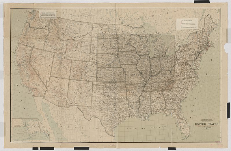
[edit]| Map of the United States Showing Fortified Areas on the Atlantic and Pacific Coasts With Location of Proposed Movable Guns
( |
||||||||||||||
|---|---|---|---|---|---|---|---|---|---|---|---|---|---|---|
| Creator | War Department. Office of the Chief of Engineers. War Department Map Collection. 1939-1942 | |||||||||||||
| Title |
Map of the United States Showing Fortified Areas on the Atlantic and Pacific Coasts With Location of Proposed Movable Guns |
|||||||||||||
| Date | 1918 | |||||||||||||
| Collection |
|
|||||||||||||
| Source/Photographer |
|
|||||||||||||
| Permission (Reusing this file) |
|
|||||||||||||
| Standardized rights statement |
|
|||||||||||||


File history
Click on a date/time to view the file as it appeared at that time.
| Date/Time | Thumbnail | Dimensions | User | Comment | |
|---|---|---|---|---|---|
| current | 03:42, 23 November 2020 | | 19,246 × 12,529 (47.87 MB) | DPLA bot (talk | contribs) | Uploading DPLA ID 6ede25638f4c8f4e426ec75e5ba068ed |
You cannot overwrite this file.
File usage on Commons
The following page uses this file: