File:Map of the Thousand Island Park on Wellesley Island, River S't Lawrence - property of the Thousand Island Camp Meeting Association LOC 2003623841.jpg
Jump to navigation
Jump to search

Size of this preview: 800 × 581 pixels. Other resolutions: 320 × 233 pixels | 640 × 465 pixels | 1,024 × 744 pixels | 1,280 × 930 pixels | 2,560 × 1,861 pixels | 7,880 × 5,727 pixels.
Original file (7,880 × 5,727 pixels, file size: 7.15 MB, MIME type: image/jpeg)
Captions
Captions
Add a one-line explanation of what this file represents
Summary
[edit]| Description |
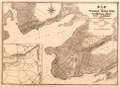
English: Cadastral map with lot lines and numbers. Relief shown by hachures. Depths shown by contours and soundings. Includes location map (inset) and list of association trustees. Available also through the Library of Congress Web site as a raster image. Acquisitions control no. 2003-65 |
||
| Title | Map of the Thousand Island Park on Wellesley Island, River S't Lawrence : property of the Thousand Island Camp Meeting Association | ||
| Shelf ID | G3804.T415 1880 .H5 | ||
| Date | |||
| Source | https://www.loc.gov/item/2003623841/ | ||
| Author | Hinds, Frank. A.; Thousand Island Camp Meeting Association | ||
| Permission (Reusing this file) |
|
||
| Other versions |
|
||
| Location | United States · New York · New York (State) · Thousand Island Park | ||
| Part of | American Memory · General Maps · Catalog · Geography And Map Division | ||
| Subject | United States · Thousand Island Park · Thousand Island Park (N.Y.) · Maps · Real Property · New York (State) |

Licensing
[edit]
|
This is a faithful photographic reproduction of a two-dimensional, public domain work of art. The work of art itself is in the public domain for the following reason:
The official position taken by the Wikimedia Foundation is that "faithful reproductions of two-dimensional public domain works of art are public domain".
This photographic reproduction is therefore also considered to be in the public domain in the United States. In other jurisdictions, re-use of this content may be restricted; see Reuse of PD-Art photographs for details. | ||||
File history
Click on a date/time to view the file as it appeared at that time.
| Date/Time | Thumbnail | Dimensions | User | Comment | |
|---|---|---|---|---|---|
| current | 03:21, 2 June 2018 | | 7,880 × 5,727 (7.15 MB) | Fæ (talk | contribs) | LOC Maps https://www.loc.gov/item/2003623841/ #2055 |
You cannot overwrite this file.
File usage on Commons
The following page uses this file: