File:Map of the Third Siege of Gerona 1809.jpg
Jump to navigation
Jump to search

Size of this preview: 800 × 510 pixels. Other resolutions: 320 × 204 pixels | 640 × 408 pixels | 1,104 × 704 pixels.
Original file (1,104 × 704 pixels, file size: 291 KB, MIME type: image/jpeg)
Captions
Captions
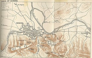
Map of the Third Siege of Gerona 1809 indicating city defenses and French deployments around the city. North is to the right.
Summary
[edit]
| Description |
English: Map of the Third Siege of Gerona 1809 indicating city defenses and French deployments around the city. From A History of the Peninsular War, Volume III by Charles Oman. Signed B.V. Darbishire 1907. |
| Date | |
| Source |
https://www.gutenberg.org/files/55231/55231-h/55231-h.htm#Chap17_3 or https://www.napoleon-series.org/images/military/maps/peninsula/gerona.jpg or http://www.pedresdegirona.com/historia_guerra_frances_1.htm or http://napoleon-monuments.eu/Napoleon1er/Gerone.htm |
| Author |
From Charles Oman, A History of the Peninsular War, Volume III. Oxford at the Clarendon Press 1908. Signed B.V. Darbishire, Oxford 1907 at lower left. |
Licensing
[edit]
This work is in the public domain in the United States because it was published (or registered with the U.S. Copyright Office) before January 1, 1929.
Public domain works must be out of copyright in both the United States and in the source country of the work in order to be hosted on the Commons. If the work is not a U.S. work, the file must have an additional copyright tag indicating the copyright status in the source country.
Note: This tag should not be used for sound recordings. |
File history
Click on a date/time to view the file as it appeared at that time.
| Date/Time | Thumbnail | Dimensions | User | Comment | |
|---|---|---|---|---|---|
| current | 14:26, 19 June 2020 | | 1,104 × 704 (291 KB) | Bdushaw (talk | contribs) | Uploaded a work by Unknown. Marked B.V. Darbishire, Oxford 1907 at lower left. from https://www.napoleon-series.org/images/military/maps/peninsula/gerona.jpg or http://www.pedresdegirona.com/historia_guerra_frances_1.htm or http://napoleon-monuments.eu/Napoleon1er/Gerone.htm with UploadWizard |
You cannot overwrite this file.
File usage on Commons
There are no pages that use this file.
File usage on other wikis
The following other wikis use this file:
- Usage on ca.wikipedia.org
- Usage on en.wikipedia.org