File:Map of the Gambier Islands and of Prospect Island (Temoe Atoll) by Capt James Duff (retouched).jpg
Jump to navigation
Jump to search

Size of this preview: 709 × 600 pixels. Other resolutions: 284 × 240 pixels | 567 × 480 pixels | 908 × 768 pixels | 1,210 × 1,024 pixels | 2,420 × 2,048 pixels | 2,698 × 2,283 pixels.
Original file (2,698 × 2,283 pixels, file size: 3.34 MB, MIME type: image/jpeg)
Captions
Captions
Add a one-line explanation of what this file represents
Summary
[edit]_by_Capt_James_Duff_(retouched).jpg&action=edit§ion=1)
| Description |
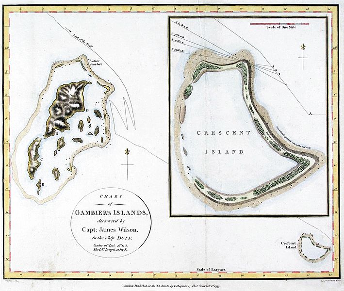
English: maps of the Gambier Islands and of Temoe Atoll (formerly Crescent Island Published in: James Wilson: A Missionary Voyage to the southern Pacific Ocean . . . T. Chapman London, 1799, after page 112 |
| Date | |
| Source | |
| Author |
|
_by_Capt._James_Duff.jpg)
| This is a retouched picture, which means that it has been digitally altered from its original version. Modifications: distorsion, color, contrast, cropped. Modifications made by Hic et nunc.
|
Licensing
[edit]_by_Capt_James_Duff_(retouched).jpg&action=edit§ion=2)
|
This work is in the public domain in its country of origin and other countries and areas where the copyright term is the author's life plus 100 years or fewer. This work is in the public domain in the United States because it was published (or registered with the U.S. Copyright Office) before January 1, 1929. | |
| This file has been identified as being free of known restrictions under copyright law, including all related and neighboring rights. | |
File history
Click on a date/time to view the file as it appeared at that time.
| Date/Time | Thumbnail | Dimensions | User | Comment | |
|---|---|---|---|---|---|
| current | 07:48, 27 January 2017 | | 2,698 × 2,283 (3.34 MB) | Hic et nunc (talk | contribs) | color |
| 07:43, 27 January 2017 |  | 2,698 × 2,283 (3.37 MB) | Hic et nunc (talk | contribs) | color | |
| 07:27, 27 January 2017 |  | 2,698 × 2,283 (3.1 MB) | Hic et nunc (talk | contribs) | =={{int:filedesc}}== {{Information |description={{en|1=maps of the Gambier Islands and of Temoe Atoll (formerly Crescent Island}} |date=late 1700s to early 1800s |source=*{{Derived from|Map of the Gambier Islands and of Prospect Island (Temoe Atoll) by... |
You cannot overwrite this file.
File usage on Commons
The following page uses this file:
File usage on other wikis
The following other wikis use this file:
- Usage on de.wikipedia.org
- Usage on fr.wikipedia.org
_by_Capt_James_Duff_(retouched).jpg&oldid=489879097)