File:Map of the City of Seattle, King County, Washington Territory, 1887 (MOHAI 13258).jpg
Original file (1,200 × 920 pixels, file size: 209 KB, MIME type: image/jpeg)
Captions
Captions
Summary
[edit].jpg&action=edit§ion=1)
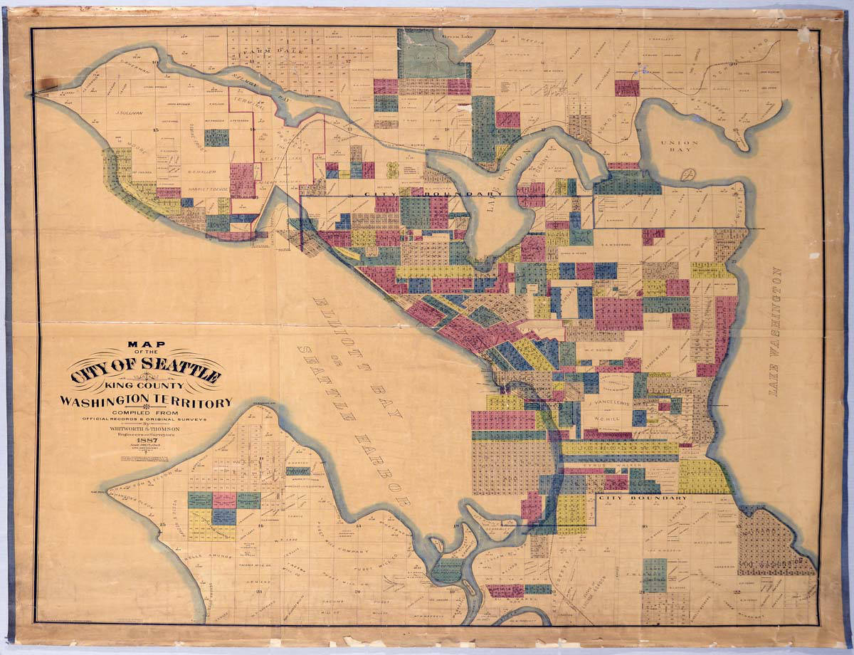
| English: Map of the City of Seattle, King County, Washington Territory, 1887
( |
||||||||||||||||||||||||
|---|---|---|---|---|---|---|---|---|---|---|---|---|---|---|---|---|---|---|---|---|---|---|---|---|
| Photographer |
English: Anderson, Oliver P. (Oliver Phelps) |
|||||||||||||||||||||||
| Title |
English: Map of the City of Seattle, King County, Washington Territory, 1887 |
|||||||||||||||||||||||
| Description |
English: R. H. (Reginald Heber) Thomson (1856-1949) was Seattle City Engineer from 1892 until 1911 and instrumental in reshaping the landscape of Seattle. Thomson was born in Hanover, Indiana, and worked as a surveyor there before heading west with his father to Oakland, California. In 1881, Thomson arrived in Seattle and soon after partnered with F. H. (Frederick Harrison) Whitworth (1846-1933), city and county surveyor. In 1884 Thomson became the Surveyor for the City of Seattle. This colorful map from Thomson & Whitworth in 1887 names plat ownership and extends beyond the Seattle city boundary to Green Lake at the north, Lake Washington to the east, and past the mouth of the Duwamish River to the south. Oliver P. Anderson, an engineer and draughtsman who would found his own company O. P. Anderson & Company in 1890, drew this map. Written on map: Map of the City of Seattle, King County, Washington Territory, Compiled from Official Records & Original Surveys by Whitworth & Thomson, Engineers & Surveyors, 1887, Scale 1000 ft. -1 inch, Lith. Britton & Rey, S. F., Entered according to act of Congress in the year 1887 by Whitworth & Thomas in the office of the Librarian of Congress at Washington. Oliver P. Anderson Draughtsman, Colored by E. M. Sleater 529 Shotwell St S. F. Caption information source: "Thomson, Reginald Heber (1856-1949)," by Alan J. Stein, HistoryLink.org Essay 2074, https://www.historylink.org/File/2074.
|
|||||||||||||||||||||||
| Depicted place |
English: United States--Washington (State)--Seattle
Washington Territory |
|||||||||||||||||||||||
| Date | 1887 | |||||||||||||||||||||||
| Medium |
English: 1 map: color |
|||||||||||||||||||||||
| Dimensions | height: 46.5 in (118.1 cm); width: 50 in (127 cm) | |||||||||||||||||||||||
| Collection |
|
|||||||||||||||||||||||
| Current location | ||||||||||||||||||||||||
| Accession number | ||||||||||||||||||||||||
| Source |
English: Museum of History and Industry |
|||||||||||||||||||||||
| Permission (Reusing this file) |
|
|||||||||||||||||||||||
| Credit Line | MOHAI, 1952.986.57.3 | |||||||||||||||||||||||
File history
Click on a date/time to view the file as it appeared at that time.
| Date/Time | Thumbnail | Dimensions | User | Comment | |
|---|---|---|---|---|---|
| current | 20:54, 27 November 2020 | | 1,200 × 920 (209 KB) | BMacZeroBot (talk | contribs) | Batch upload (Commons:Batch uploading/University of Washington Digital Collections) |
You cannot overwrite this file.
File usage on Commons
The following page uses this file:
.jpg)
.jpg&oldid=806111901)