File:Map of road construction, Guantanamo detention camp, March 2015.jpg
Jump to navigation
Jump to search
No higher resolution available.
Map_of_road_construction,_Guantanamo_detention_camp,_March_2015.jpg (675 × 512 pixels, file size: 269 KB, MIME type: image/jpeg)
Captions
Captions
Add a one-line explanation of what this file represents
| Description |
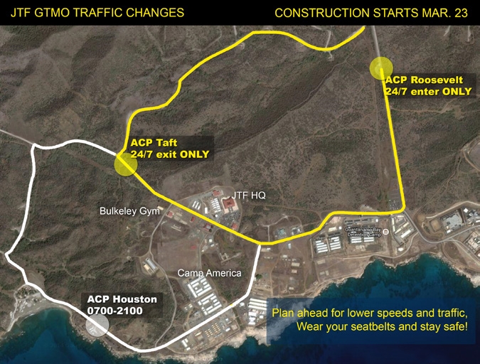
Map of road construction, Guantanamo detention camp, March 2015 ACP Roosevelt, ACP Taft and ACP Houston are "access control points". |
|||
| Date | ||||
| Source |
https://commons.wikimedia.org/w/index.php?title=File:The_Wire_Issue20v17.pdf&page=4 http://www.jtfgtmo.southcom.mil/wire/pdf/v17/TheWire17-20.pdf#page=4 |
|||
| Author | JTF-GTMO | |||
| Permission (Reusing this file) |
|

File history
Click on a date/time to view the file as it appeared at that time.
| Date/Time | Thumbnail | Dimensions | User | Comment | |
|---|---|---|---|---|---|
| current | 03:17, 14 March 2015 | | 675 × 512 (269 KB) | Geo Swan (talk | contribs) | {{Information |Description=Map of road construction, Guantanamo detention camp, March 2015 |Source=http://www.jtfgtmo.southcom.mil/wire/pdf/v17/TheWire17-20.pdf |Date=March 2015 |Author=JTF-GTMO |Permission={{PD-USGov-Military}} |other_versions= }} [[... |
You cannot overwrite this file.
File usage on Commons
The following page uses this file: