File:Map of population density, South Australia and southern Northern Territory (2018) with railway lines to Alice Springs overlaid.png
Jump to navigation
Jump to search

Size of this preview: 411 × 599 pixels. Other resolutions: 164 × 240 pixels | 329 × 480 pixels | 527 × 768 pixels | 702 × 1,024 pixels | 1,529 × 2,229 pixels.
Original file (1,529 × 2,229 pixels, file size: 1.21 MB, MIME type: image/png)
Captions
Captions
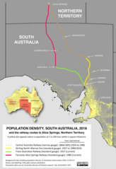
Map of population density, South Australia and southern Northern Territory (2018) with railway lines to Alice Springs overlaid
Summary
[edit]_with_railway_lines_to_Alice_Springs_overlaid.png&action=edit§ion=1)
| Description |
English: Map of population density in South Australia and the southern part of the Northern Territory in 2018 (© Australian Government 2020). The routes of past and present railway lines from Port Augusta / Stirling North to Alice Springs are overlaid on the map (CC0 SCHolar44), demonstrating the extremely low populations along the routes. Settlements on the route of the former Central Australia Railway, which closed in 1980, are much diminished in population but still trace the railway's route. |
| Date | |
| Source | Australian Bureau of Statistics -- https://www.abs.gov.au/AUSSTATS/abs@.nsf/DetailsPage/3218.02017-18 |
| Author | Australian Bureau of Statistics staff |
Licensing
[edit]_with_railway_lines_to_Alice_Springs_overlaid.png&action=edit§ion=2)
This file is licensed under the Creative Commons Attribution 4.0 International license.
Attribution: Australian Government
The Australian Government owns copyright in this work. Under its Public Data Policy, it has made non-sensitive data open by default, with licensing under a Creative Commons BY Attribution licence.
The Australian Government owns copyright in this work. Under its Public Data Policy, it has made non-sensitive data open by default, with licensing under a Creative Commons BY Attribution licence.
- You are free:
- to share – to copy, distribute and transmit the work
- to remix – to adapt the work
- Under the following conditions:
- attribution – You must give appropriate credit, provide a link to the license, and indicate if changes were made. You may do so in any reasonable manner, but not in any way that suggests the licensor endorses you or your use.
File history
Click on a date/time to view the file as it appeared at that time.
| Date/Time | Thumbnail | Dimensions | User | Comment | |
|---|---|---|---|---|---|
| current | 10:23, 14 July 2020 | | 1,529 × 2,229 (1.21 MB) | SCHolar44 (talk | contribs) | Uploaded a work by Australian Bureau of Statistics staff from Australian Bureau of Statistics -- https://www.abs.gov.au/AUSSTATS/abs@.nsf/DetailsPage/3218.02017-18 with UploadWizard |
You cannot overwrite this file.
File usage on Commons
There are no pages that use this file.
File usage on other wikis
The following other wikis use this file:
- Usage on hu.wikipedia.org
_with_railway_lines_to_Alice_Springs_overlaid.png&oldid=724836800)