File:Map of central Franz Josef Land-en.svg
Jump to navigation
Jump to search

Size of this PNG preview of this SVG file: 362 × 523 pixels. Other resolutions: 166 × 240 pixels | 332 × 480 pixels | 531 × 768 pixels | 709 × 1,024 pixels | 1,417 × 2,048 pixels.
Original file (SVG file, nominally 362 × 523 pixels, file size: 346 KB)
Captions
Captions
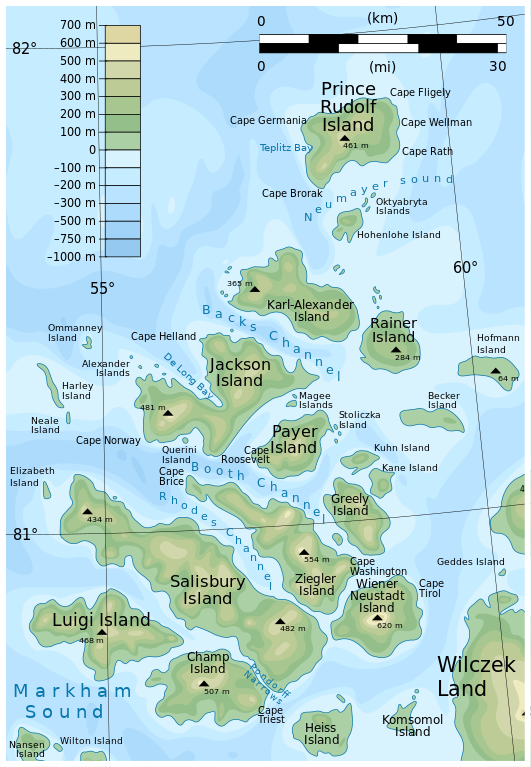
Map of central Franz Josef Land
Summary
[edit]
| Description |
English: Map of central Franz Josef Land |
| Date | |
| Source | File:Map of Franz Josef Land-en.svg adapted by User:Aymatth2 |
| Author | User:Mysid |
Licensing
[edit]
This file is licensed under the Creative Commons Attribution-Share Alike 3.0 Unported license.
- You are free:
- to share – to copy, distribute and transmit the work
- to remix – to adapt the work
- Under the following conditions:
- attribution – You must give appropriate credit, provide a link to the license, and indicate if changes were made. You may do so in any reasonable manner, but not in any way that suggests the licensor endorses you or your use.
- share alike – If you remix, transform, or build upon the material, you must distribute your contributions under the same or compatible license as the original.
File history
Click on a date/time to view the file as it appeared at that time.
| Date/Time | Thumbnail | Dimensions | User | Comment | |
|---|---|---|---|---|---|
| current | 13:23, 18 July 2013 | | 362 × 523 (346 KB) | Aymatth2 (talk | contribs) | User created page with UploadWizard |
You cannot overwrite this file.
File usage on Commons
The following page uses this file:
File usage on other wikis
The following other wikis use this file:
- Usage on ast.wikipedia.org
- Usage on avk.wikipedia.org
- Luigi (ewala)
- Salisbury (ewala)
- Champ (ewala)
- Ziegler (ewala)
- Wiener Neustadt (ewala)
- Greely (ewala)
- Kane (ewala)
- Kuhn (ewala)
- Payer (ewala)
- Jackson (ewala)
- Karl-Alexander (ewala)
- Rainer (ewala)
- Hohenlohe (ewala)
- Prince Rudolf (ewala)
- Becker (ewala)
- Hofmann (ewala)
- Torup (ewala)
- Coburg (ewala)
- Querini (ewala)
- Ommanney (ewala)
- Harley (ewala)
- Levanevsky (ewala)
- Elisabeth (ewala)
- Brosch (ewala)
- Howen (ewala)
- Usage on az.wikipedia.org
- Usage on ca.wikipedia.org
- Usage on cs.wikipedia.org
- Usage on de.wikipedia.org
- Usage on el.wikipedia.org
- Usage on en.wikipedia.org
View more global usage of this file.