File:Map of a part of the eastern portion of Virginia showing the route of the Cavalry Corps of the Army of the Potomac under Major General P.H. Sheridan on the raid to Richmond in May 1864 - together with LOC 2006627693.jpg
Jump to navigation
Jump to search
Size of this preview: 357 × 599 pixels. Other resolutions: 143 × 240 pixels | 286 × 480 pixels | 457 × 768 pixels | 610 × 1,024 pixels | 1,220 × 2,048 pixels | 3,742 × 6,281 pixels.
Original file (3,742 × 6,281 pixels, file size: 3.28 MB, MIME type: image/jpeg)
Captions
Captions
Add a one-line explanation of what this file represents
Summary
[edit]| Description |
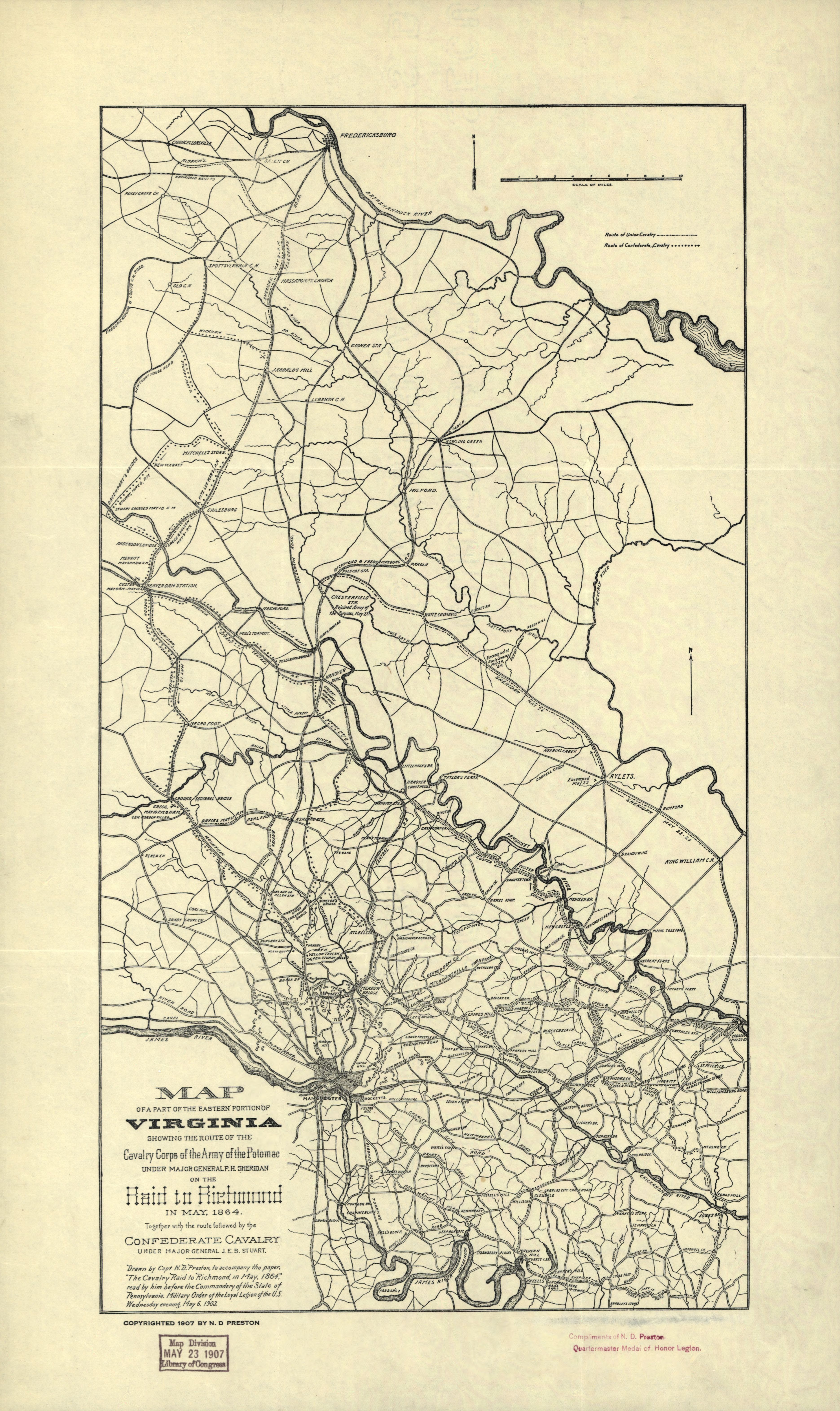
English: Covers Richmond region (Va.) northward to Fredericksburg. Shows cavalry routes of movement, engagements, encampments, roads, railroads, settlements, drainage, and the fortifications around Richmond. "Drawn by Capt. N.D. Preston, to accompany the paper, 'The Cavalry Raid to Richmond in May 1864', read by him before the Commandery of the State of Pennsylvania, Military Order of the Loyal Legion of the U.S., Wednesday evening, May 6, 1903." Stamped in red ink in lower right corner: "Compliments of N.D. Preston, Quartermaster Medal of Honor Legion." LC Civil War Maps (2nd ed.), 496 Available also through the Library of Congress website as raster image. |
||
| Title | Map of a part of the eastern portion of Virginia showing the route of the Cavalry Corps of the Army of the Potomac under Major General P.H. Sheridan on the raid to Richmond in May 1864 : together with the route followed by the Confederate Cavalry under Major General J.E.B. Stuart | ||
| Shelf ID | G3884.R5S5 1907 .P7 | ||
| Date | |||
| Source | https://www.loc.gov/item/2006627693/ | ||
| Author | Preston, Noble D.; Military Order Of The Loyal Legion Of The United States | ||
| Permission (Reusing this file) |
|
||
| Other versions |
|
||
| Location | United States · Richmond Region · Virginia | ||
| Part of | Military Battles And Campaigns · American Memory · Civil War Maps · Catalog · Geography And Map Division | ||
| Subject | Fortification · Richmond Region · Virginia · Civil War · United States · Maps · Richmond Region (Va.) · History |

Licensing
[edit]
|
This is a faithful photographic reproduction of a two-dimensional, public domain work of art. The work of art itself is in the public domain for the following reason:
The official position taken by the Wikimedia Foundation is that "faithful reproductions of two-dimensional public domain works of art are public domain".
This photographic reproduction is therefore also considered to be in the public domain in the United States. In other jurisdictions, re-use of this content may be restricted; see Reuse of PD-Art photographs for details. | ||||
File history
Click on a date/time to view the file as it appeared at that time.
| Date/Time | Thumbnail | Dimensions | User | Comment | |
|---|---|---|---|---|---|
| current | 10:36, 15 May 2018 | | 3,742 × 6,281 (3.28 MB) | Fæ (talk | contribs) | LOC Maps https://www.loc.gov/item/2006627693/ #8870 |
You cannot overwrite this file.
File usage on Commons
The following page uses this file: