File:Map of Worth (County, Iowa). LOC 2012593142.jpg
Jump to navigation
Jump to search

Size of this preview: 393 × 599 pixels. Other resolutions: 157 × 240 pixels | 315 × 480 pixels | 504 × 768 pixels | 672 × 1,024 pixels | 1,344 × 2,048 pixels | 6,245 × 9,516 pixels.
Original file (6,245 × 9,516 pixels, file size: 7.62 MB, MIME type: image/jpeg)
Captions
Captions
Add a one-line explanation of what this file represents
Summary
[edit]| Description |
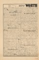
English: Shows landowners. LC Land ownership maps, 210 Available also through the Library of Congress Web site as a raster image. Pencil annotation in upper left corner: compiled, published + copyrighted by E.H. Dwelle. LC copy imperfect: left sheet/portion of map only. |
||
| Title | Map of Worth [County, Iowa]. | ||
| Shelf ID | G4153.W8 1894 .D9 G4153.W8 1894 .D9 | ||
| Date | |||
| Source | https://www.loc.gov/item/2012593142/ | ||
| Author | Dwelle, E. H. | ||
| Permission (Reusing this file) |
|
||
| Other versions |
|
||
| Location | United States · Worth County · Iowa | ||
| Part of | American Memory · Catalog · County Landownership Maps · Geography And Map Division · Cultural Landscapes | ||
| Subject | Cadastral Maps · Worth County · Iowa · United States · Maps · Worth County (Iowa) · Real Property · Landowners |

._LOC_2012593142.jpg&action=edit§ion=1)
Licensing
[edit]._LOC_2012593142.jpg&action=edit§ion=2)
|
This is a faithful photographic reproduction of a two-dimensional, public domain work of art. The work of art itself is in the public domain for the following reason:
The official position taken by the Wikimedia Foundation is that "faithful reproductions of two-dimensional public domain works of art are public domain".
This photographic reproduction is therefore also considered to be in the public domain in the United States. In other jurisdictions, re-use of this content may be restricted; see Reuse of PD-Art photographs for details. | ||||
File history
Click on a date/time to view the file as it appeared at that time.
| Date/Time | Thumbnail | Dimensions | User | Comment | |
|---|---|---|---|---|---|
| current | 13:35, 5 June 2018 | | 6,245 × 9,516 (7.62 MB) | Fæ (talk | contribs) | LOC Maps https://www.loc.gov/item/2012593142/ #20858 |
You cannot overwrite this file.
File usage on Commons
The following 2 pages use this file:
._LOC_2012593142.jpg&oldid=697369215)