File:Map of Ur III mk.svg
Jump to navigation
Jump to search

Size of this PNG preview of this SVG file: 360 × 400 pixels. Other resolutions: 216 × 240 pixels | 432 × 480 pixels | 691 × 768 pixels | 922 × 1,024 pixels | 1,843 × 2,048 pixels.
Original file (SVG file, nominally 360 × 400 pixels, file size: 526 KB)
Captions
Captions
Add a one-line explanation of what this file represents
Summary
[edit]| Description |
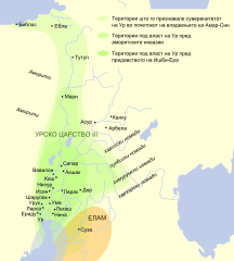
Македонски: Карта на царството на Третата урска династија во рамките на Месопотамија (XX век п.н.е.)
English: Map in Macedonian showing the extents of the Ur III Empire in Mesopotamia circa the 22nd century BCE. |
| Date | (UTC) |
| Source |
This file was derived from: Map of Ur III.svg:  |
| Author |
|
| Other versions |
|

| This is a retouched picture, which means that it has been digitally altered from its original version. Modifications: Translated to Macedonian. The original can be viewed here: Map of Ur III.svg:
|
Licensing
[edit]
I, the copyright holder of this work, hereby publish it under the following license:
This file is licensed under the Creative Commons Attribution-Share Alike 3.0 Unported license.
- You are free:
- to share – to copy, distribute and transmit the work
- to remix – to adapt the work
- Under the following conditions:
- attribution – You must give appropriate credit, provide a link to the license, and indicate if changes were made. You may do so in any reasonable manner, but not in any way that suggests the licensor endorses you or your use.
- share alike – If you remix, transform, or build upon the material, you must distribute your contributions under the same or compatible license as the original.
Original upload log
[edit]
This image is a derivative work of the following images:
- File:Map_of_Ur_III.svg licensed with Cc-by-sa-3.0
- 2010-01-01T01:00:33Z Chaim The Bipolar 350x400 (334080 Bytes) {{Information |Description={{en|This map shows the extents of the Ur III Empire in Mesopotamia circa the 22nd century BCE}} {{es|Mapa de la extensión del imperio de la Tercera Dinastía de Ur en Mesopotamia y el Oriente Pr�
Uploaded with derivativeFX
File history
Click on a date/time to view the file as it appeared at that time.
| Date/Time | Thumbnail | Dimensions | User | Comment | |
|---|---|---|---|---|---|
| current | 02:25, 10 December 2012 | | 360 × 400 (526 KB) | Bjankuloski06en (talk | contribs) | == {{int:filedesc}} == {{Information |Description={{mk|Карта на царството на Третата урска династија во рамките на Месопотамија (XX век п.н.е.)}} {{en|Map in Macedonian sh... |
You cannot overwrite this file.
File usage on Commons
The following 2 pages use this file:
File usage on other wikis
The following other wikis use this file:
- Usage on mk.wikipedia.org