File:Map of USA with HPV uptake.svg
Jump to navigation
Jump to search

Size of this PNG preview of this SVG file: 800 × 494 pixels. Other resolutions: 320 × 198 pixels | 640 × 395 pixels | 1,024 × 633 pixels | 1,280 × 791 pixels | 2,560 × 1,582 pixels | 955 × 590 pixels.
Original file (SVG file, nominally 955 × 590 pixels, file size: 713 KB)
Captions
Captions
Add a one-line explanation of what this file represents
| Description |
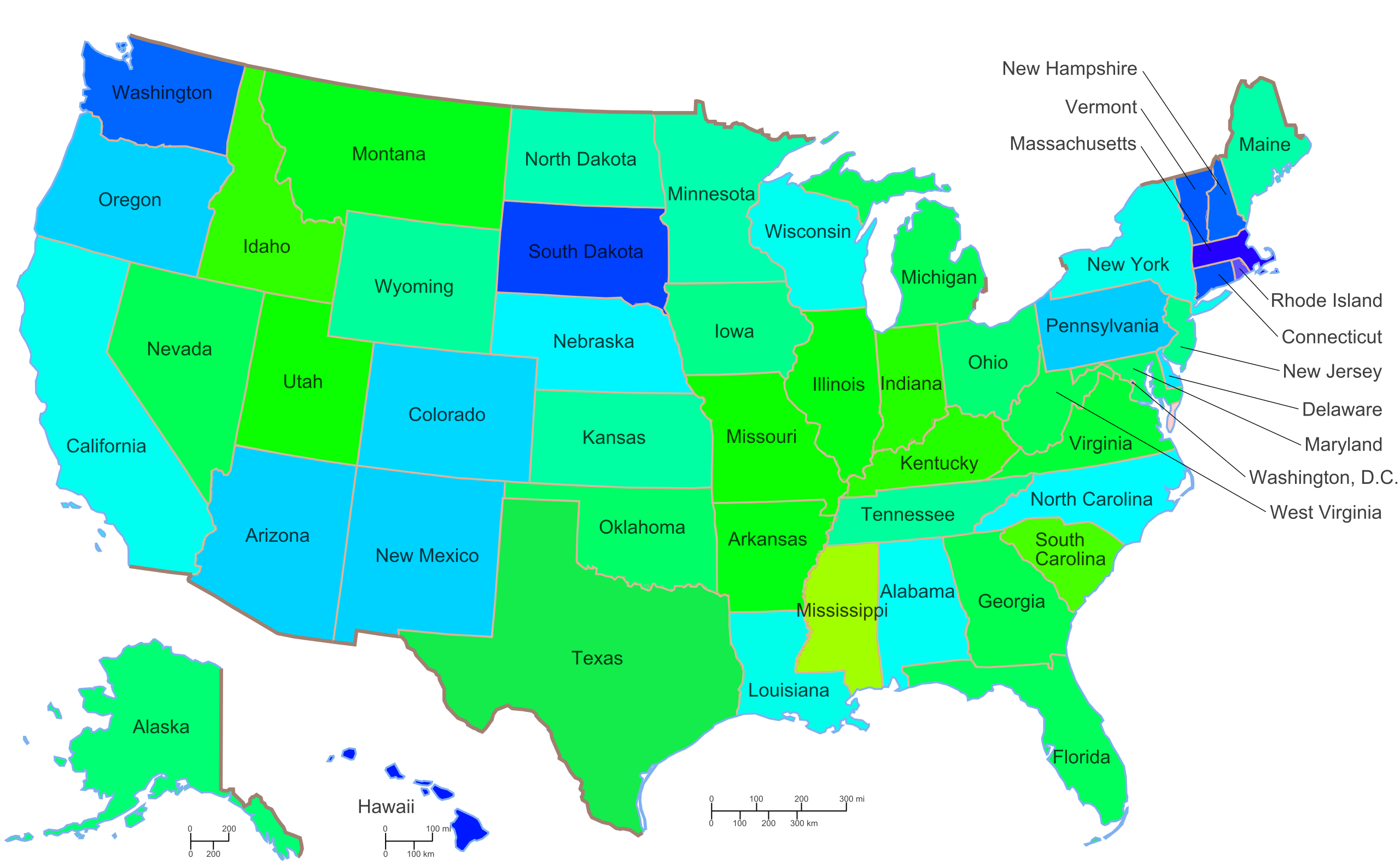
English: Colour hue for each state altered to reflect HPV (>=1 dose) uptake.
% uptake /100 * 255 = hue HPV data: NIS-Teen 2009 |
| Date | (UTC) |
| Source | |
| Author |
|
| This is a retouched picture, which means that it has been digitally altered from its original version. Modifications: Coloured to reflect HPV uptake. The original can be viewed here: Map of USA with state names 2.svg:
|
I, the copyright holder of this work, hereby publish it under the following licenses:
This file is licensed under the Creative Commons Attribution-Share Alike 3.0 Unported, 2.5 Generic, 2.0 Generic and 1.0 Generic license.
- You are free:
- to share – to copy, distribute and transmit the work
- to remix – to adapt the work
- Under the following conditions:
- attribution – You must give appropriate credit, provide a link to the license, and indicate if changes were made. You may do so in any reasonable manner, but not in any way that suggests the licensor endorses you or your use.
- share alike – If you remix, transform, or build upon the material, you must distribute your contributions under the same or compatible license as the original.
| This file is licensed under the Creative Commons Attribution-Share Alike 3.0 Unported license. | ||
| ||
| This licensing tag was added to this file as part of the GFDL licensing update. |

|
Permission is granted to copy, distribute and/or modify this document under the terms of the GNU Free Documentation License, Version 1.2 or any later version published by the Free Software Foundation; with no Invariant Sections, no Front-Cover Texts, and no Back-Cover Texts. A copy of the license is included in the section entitled GNU Free Documentation License. |
You may select the license of your choice.
Original upload log
[edit]
This image is a derivative work of the following images:
- File:Map_of_USA_with_state_names_2.svg licensed with Cc-by-sa-3.0,2.5,2.0,1.0, Cc-by-sa-3.0-migrated, GFDL
- 2010-06-27T04:39:35Z ZooFari 955x590 (731062 Bytes) Removed border, Washington, D.C.
- 2010-01-01T18:41:06Z ZooFari 959x593 (812442 Bytes) {{validSVG}} ==Clickable version== Image:Map of USA with state names.svg|400px|left poly 643 371 666 452 621 458 621 473 606 468 604 374 [[Alabama]] poly 152 457 153 540 177 548 205 576 205 589 183 588 158 553 117 547 100 5
Uploaded with derivativeFX
File history
Click on a date/time to view the file as it appeared at that time.
| Date/Time | Thumbnail | Dimensions | User | Comment | |
|---|---|---|---|---|---|
| current | 15:24, 13 February 2011 | | 955 × 590 (713 KB) | Lachlanfotheringham (talk | contribs) | {{Information |Description=Colour hue for each state altered to reflect HPV (>=1 dose) uptake. % uptake /100 * 255 = hue HPV data: NIS-Teen 2009 |Source=*File:Map_of_USA_with_state_names_2.svg |Date=2011-02-13 15:22 (UTC) |Author=*[[:File:Map_of_U |
You cannot overwrite this file.
File usage on Commons
There are no pages that use this file.