File:Map of USA AB.png
Jump to navigation
Jump to search
No higher resolution available.
Map_of_USA_AB.png (286 × 186 pixels, file size: 32 KB, MIME type: image/png)
Captions
Captions
Add a one-line explanation of what this file represents
Summary
[edit]
| Description |
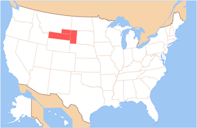
English: Outlines the state borders of the proposed State of Absaroka |
| Date | (UTC) |
| Source | Own work by Brightgalrs, based on :Image:Map of USA without state names.svg |
| Author |
This version: Brightgalrs Base versions this one is derived from: originally created by : en:User:Wapcaplet |
Licensing
[edit]
This file is licensed under the Creative Commons Attribution-Share Alike 3.0 Unported license.
- You are free:
- to share – to copy, distribute and transmit the work
- to remix – to adapt the work
- Under the following conditions:
- attribution – You must give appropriate credit, provide a link to the license, and indicate if changes were made. You may do so in any reasonable manner, but not in any way that suggests the licensor endorses you or your use.
- share alike – If you remix, transform, or build upon the material, you must distribute your contributions under the same or compatible license as the original.
Original upload log
[edit]
The original description page was here. All following user names refer to en.wikipedia.
| Date/Time | Dimensions | User | Comment |
|---|---|---|---|
| 2010-10-11 23:44 | 286×186× (33008 bytes) | Brightgalrs | {{Information |Description = Outlines the state borders of the proposed [[State of Jefferson]] |Source = Own work by uploader, based on [[:Image:Map of USA without state names.svg]] |Date = 02:39, 18 September 2010 (UTC) |Author |
File history
Click on a date/time to view the file as it appeared at that time.
| Date/Time | Thumbnail | Dimensions | User | Comment | |
|---|---|---|---|---|---|
| current | 14:42, 15 June 2015 | | 286 × 186 (32 KB) | BD2412 (talk | contribs) | Transferred from en.wikipedia |
You cannot overwrite this file.
File usage on Commons
The following page uses this file:
File usage on other wikis
The following other wikis use this file:
- Usage on fr.wikipedia.org
- Usage on ru.wikipedia.org
- Usage on uz.wikipedia.org
- Usage on www.wikidata.org