File:Map of Troy, also West Troy, and Green Island LOC 2011593681.jpg
Jump to navigation
Jump to search

Size of this preview: 471 × 600 pixels. Other resolutions: 188 × 240 pixels | 377 × 480 pixels | 603 × 768 pixels | 804 × 1,024 pixels | 1,609 × 2,048 pixels | 6,498 × 8,272 pixels.
Original file (6,498 × 8,272 pixels, file size: 7.93 MB, MIME type: image/jpeg)
Captions
Captions
Add a one-line explanation of what this file represents
Summary
[edit]| Description |
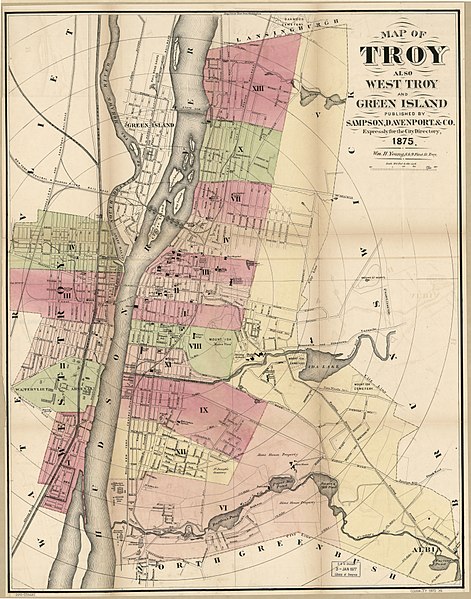
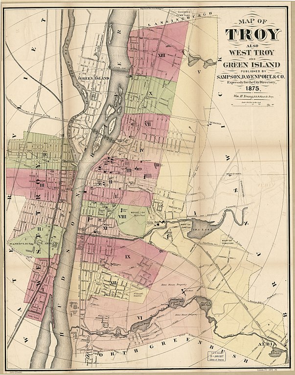
English: Shows radial distances from court house. Hand col. to show ward areas, ward numbers, principal buildings, and railroads. "Published by Sampson, Davenport & Co. expressly for the city directory." Available also through the Library of Congress Web site as a raster image. LC copy imperfect: Torn at left margin, also at fold lines, removed from city directory. |
||
| Title | Map of Troy, also West Troy, and Green Island | ||
| Shelf ID | G3804.T7 1875 .Y6 | ||
| Date | |||
| Source | https://www.loc.gov/item/2011593681/ | ||
| Author | Young, William H.; Sampson, Davenport & Co. | ||
| Permission (Reusing this file) |
|
||
| Other versions |
|
||
| Location | Green Island · United States · Troy · New York · New York (State) · Watervliet | ||
| Part of | American Memory · Cities And Towns · Catalog · Geography And Map Division | ||
| Subject | New York (State) · Green Island · Green Island (N.Y.) · United States · Maps · Troy · Administrative And Political Divisions · Troy (N.Y.) · Watervliet · Watervliet (N.Y.) |


Licensing
[edit]
|
This is a faithful photographic reproduction of a two-dimensional, public domain work of art. The work of art itself is in the public domain for the following reason:
The official position taken by the Wikimedia Foundation is that "faithful reproductions of two-dimensional public domain works of art are public domain".
This photographic reproduction is therefore also considered to be in the public domain in the United States. In other jurisdictions, re-use of this content may be restricted; see Reuse of PD-Art photographs for details. | ||||
File history
Click on a date/time to view the file as it appeared at that time.
| Date/Time | Thumbnail | Dimensions | User | Comment | |
|---|---|---|---|---|---|
| current | 13:43, 15 May 2018 | | 6,498 × 8,272 (7.93 MB) | Fæ (talk | contribs) | LOC Maps https://www.loc.gov/item/2011593681/ #8977 |
You cannot overwrite this file.
File usage on Commons
The following page uses this file: