File:Map of Tarnobrzeg - 1853.jpg
Jump to navigation
Jump to search

Size of this preview: 573 × 599 pixels. Other resolutions: 229 × 240 pixels | 591 × 618 pixels.
Original file (591 × 618 pixels, file size: 69 KB, MIME type: image/jpeg)
Captions
Captions
Add a one-line explanation of what this file represents
Summary
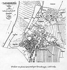
[edit]| Description | map of Tarnobrzeg - 1853 | |||
| Date | ||||
| Source | http://tbc.tarnobrzeg.pl/Content/4742/ppzs11.pdf | |||
| Author | unknown | |||
| Permission (Reusing this file) |
|

File history
Click on a date/time to view the file as it appeared at that time.
| Date/Time | Thumbnail | Dimensions | User | Comment | |
|---|---|---|---|---|---|
| current | 17:38, 1 January 2024 | | 591 × 618 (69 KB) | FLLL (talk | contribs) | {{Information |Description= map of Tarnobrzeg - 1853 |Source= http://tbc.tarnobrzeg.pl/Content/4742/ppzs11.pdf |Date= 1853 |Author= unknown |Permission= {{PD-Polish}} |other_versions= }} Category:Maps of Tarnobrzeg Category:Old maps of cities |
You cannot overwrite this file.
File usage on Commons
There are no pages that use this file.