File:Map of South Pittsburg, Tennessee. LOC gm71000028.jpg
Jump to navigation
Jump to search

Size of this preview: 490 × 599 pixels. Other resolutions: 196 × 240 pixels | 392 × 480 pixels | 628 × 768 pixels | 837 × 1,024 pixels | 1,674 × 2,048 pixels | 7,931 × 9,702 pixels.
Original file (7,931 × 9,702 pixels, file size: 8.81 MB, MIME type: image/jpeg)
Captions
Captions
Add a one-line explanation of what this file represents
Summary
[edit]| Description |
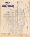
English: Scale ca. 1:2,600. Photocopy; blue line print. Cadastral map. Available also through the Library of Congress Web site as a raster image. AACR2: 651 |
||
| Title | Map of South Pittsburg, Tennessee. | ||
| Shelf ID | G3964.S69 1887 .C5 | ||
| Date | |||
| Source | https://www.loc.gov/item/gm71000028/ | ||
| Author | Clute, F. P.; South Pittsburg City Company | ||
| Permission (Reusing this file) |
|
||
| Other versions |
|
||
| Location | United States · South Pittsburg. · South Pittsburg · Tennessee | ||
| Part of | American Memory · Cities And Towns · Catalog · Geography And Map Division | ||
| Subject | United States · Maps · South Pittsburg · Tennessee · South Pittsburg (Tenn.) |

Licensing
[edit]
|
This is a faithful photographic reproduction of a two-dimensional, public domain work of art. The work of art itself is in the public domain for the following reason:
The official position taken by the Wikimedia Foundation is that "faithful reproductions of two-dimensional public domain works of art are public domain".
This photographic reproduction is therefore also considered to be in the public domain in the United States. In other jurisdictions, re-use of this content may be restricted; see Reuse of PD-Art photographs for details. | ||||
File history
Click on a date/time to view the file as it appeared at that time.
| Date/Time | Thumbnail | Dimensions | User | Comment | |
|---|---|---|---|---|---|
| current | 23:40, 8 January 2019 | | 7,931 × 9,702 (8.81 MB) | Fæ (talk | contribs) | LOC Maps https://www.loc.gov/item/gm71000028/ #783 |
You cannot overwrite this file.
File usage on Commons
The following page uses this file: