File:Map of Schoharie Co., New York LOC 2008620859.jpg
Jump to navigation
Jump to search

Size of this preview: 413 × 599 pixels. Other resolutions: 165 × 240 pixels | 331 × 480 pixels | 530 × 768 pixels | 706 × 1,024 pixels | 1,413 × 2,048 pixels | 11,651 × 16,890 pixels.
Original file (11,651 × 16,890 pixels, file size: 33.09 MB, MIME type: image/jpeg)
Captions
Captions
Add a one-line explanation of what this file represents
Summary
[edit]| Warning | The original file is very high-resolution. It might not load properly or could cause your browser to freeze when opened at full size. |
|---|
| Description |
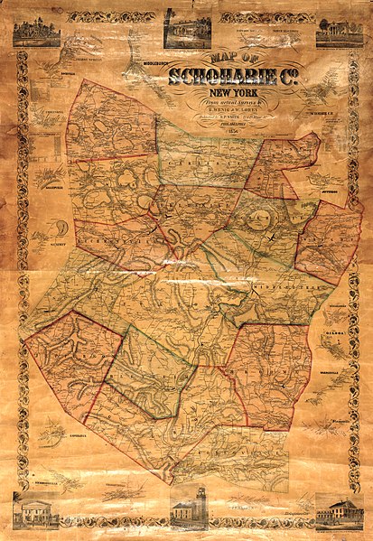
English: General county wall map showing townships (hand col.), roads, buildings, and householders' names. Relief shown by hachures. In lower margin: Entered according to act of Congress in the year 1856 by Robert P. Smith in the Clerk's Office of the district court of the eastern district of Pennsylvania. LC copy imperfect: Brittle, cracked, shellacked, cloth backing hemmed at left/right sheet edges, wooden rods removed from top/bottom edges of sheet. Includes 17 village insets (including Schoharie C.H. and Cobleskill), statistical tables, and ill. of prominent buildings. Available also through the Library of Congress Web site as a raster image. Acquisitions control no.: 1999-009 Copies 2 and 3 are filed in map drawer. |
||
| Title | Map of Schoharie Co., New York | ||
| Shelf ID | G3803.S5 1856 .W4 G3803.S5 1856 .W4 G3803.S5 1856 .W4 | ||
| Date | |||
| Source | https://www.loc.gov/item/2008620859/ | ||
| Author | Wenig, E.; Lorey, Wm. (William); Smith, Robert Pearsall | ||
| Permission (Reusing this file) |
|
||
| Location | Schoharie County · United States · New York · Cobleskill · New York (State) · Schoharie | ||
| Part of | American Memory · Catalog · County Landownership Maps · Geography And Map Division · Cultural Landscapes | ||
| Subject | Buildings · Villages · Schoharie (N.Y.) · Cities And Towns · Schoharie County (N.Y.) · Schoharie County · Schoharie · United States · Maps · Cobleskill (N.Y.) · Administrative And Political Divisions · Cobleskill · New York (State) · Landowners |

Licensing
[edit]
|
This is a faithful photographic reproduction of a two-dimensional, public domain work of art. The work of art itself is in the public domain for the following reason:
The official position taken by the Wikimedia Foundation is that "faithful reproductions of two-dimensional public domain works of art are public domain".
This photographic reproduction is therefore also considered to be in the public domain in the United States. In other jurisdictions, re-use of this content may be restricted; see Reuse of PD-Art photographs for details. | ||||
File history
Click on a date/time to view the file as it appeared at that time.
| Date/Time | Thumbnail | Dimensions | User | Comment | |
|---|---|---|---|---|---|
| current | 06:51, 10 May 2018 | | 11,651 × 16,890 (33.09 MB) | Fæ (talk | contribs) | LOC Maps https://www.loc.gov/item/2008620859/ #2299 |
You cannot overwrite this file.
File usage on Commons
There are no pages that use this file.