File:Map of Queenstown.jpg
Original file (1,951 × 1,533 pixels, file size: 808 KB, MIME type: image/jpeg)
Captions
Captions
Summary
[edit]
| Description |
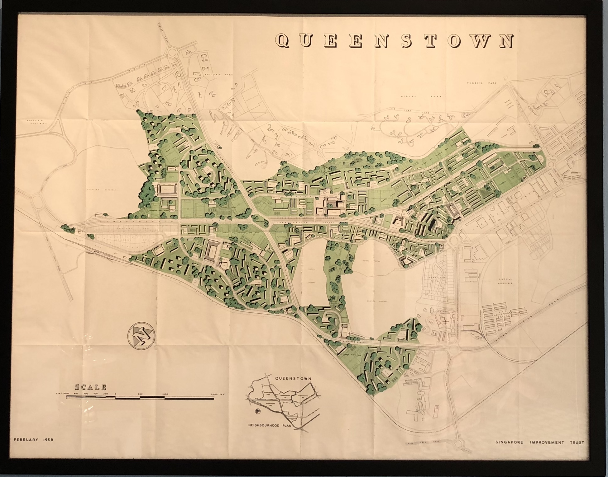
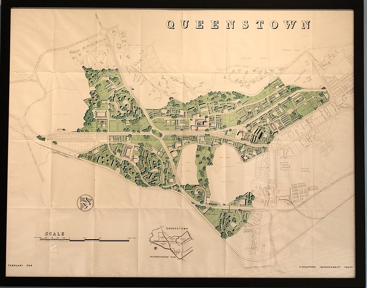
English: This map, created by Singapore Improvement Trust (SIT) in 1958, carries with it Queenstown’s rich history as Singapore’s first satellite town, constructed by SIT in 1953. In 1960, Housing Development Board (HDB) took over the role of SIT, continuing to build and expand Queenstown in its 5-year building programme (1960-1965), further developing Queenstown as part of a solution to relieve the acute congestion in the city centre.
These 1,150 acres (465 ha) were enclosed by Alexandra Road, Holland Road, North Buona Vista, the Malayan Railway and Tanglin Road, and was named in commemoration of Queen Elizabeth II’s coronation in 1953. SIT’s New Towns Working Party (created in 1954) laid down the principles by which Queenstown was to be planned and developed. A total of 5 neighbourhoods were planned, and the first to be completed was Princess Estate in 1956. The principal commercial centre was in Neighbourhood II, between Commonwealth Avenue and Margaret Drive, where the main community buildings, post office and cinema would be. The Working Party was to oversee the siting, landscaping, and architectural design of Queenstown’s buildings. As Queenstown was first and foremost created for those displaced from slum clearance schemes, planners feared the town would end up housing people from lower income levels. To mitigate this issue, the Working Party proposed that professionals and business people from middle to upper income levels should be encouraged to settle in Queenstown. These efforts at creating socio-economic variation and diversity within the neighbourhood was directed at fulfilling Queenstown’s intended function – to be a “self-contained and balanced community” with a unique identity. https://mycommunity.wikibase.cloud/wiki/Item:Q36 |
| Date | |
| Source | Own work |
| Author | Mycommunitysg |
| Camera location | | View this and other nearby images on: OpenStreetMap |
|---|
Licensing
[edit]
- You are free:
- to share – to copy, distribute and transmit the work
- to remix – to adapt the work
- Under the following conditions:
- attribution – You must give appropriate credit, provide a link to the license, and indicate if changes were made. You may do so in any reasonable manner, but not in any way that suggests the licensor endorses you or your use.
- share alike – If you remix, transform, or build upon the material, you must distribute your contributions under the same or compatible license as the original.
File history
Click on a date/time to view the file as it appeared at that time.
| Date/Time | Thumbnail | Dimensions | User | Comment | |
|---|---|---|---|---|---|
| current | 06:21, 11 November 2023 | | 1,951 × 1,533 (808 KB) | Mycommunitysg (talk | contribs) | Uploaded own work with UploadWizard |
You cannot overwrite this file.
File usage on Commons
There are no pages that use this file.