File:Map of Palestine or the Holy Land (FL37128357 3904902).jpg
Jump to navigation
Jump to search

Size of this preview: 800 × 560 pixels. Other resolutions: 320 × 224 pixels | 640 × 448 pixels | 1,024 × 717 pixels | 1,280 × 897 pixels | 2,560 × 1,793 pixels | 3,195 × 2,238 pixels.
Original file (3,195 × 2,238 pixels, file size: 4.21 MB, MIME type: image/jpeg)
Captions
Captions
Add a one-line explanation of what this file represents
Summary
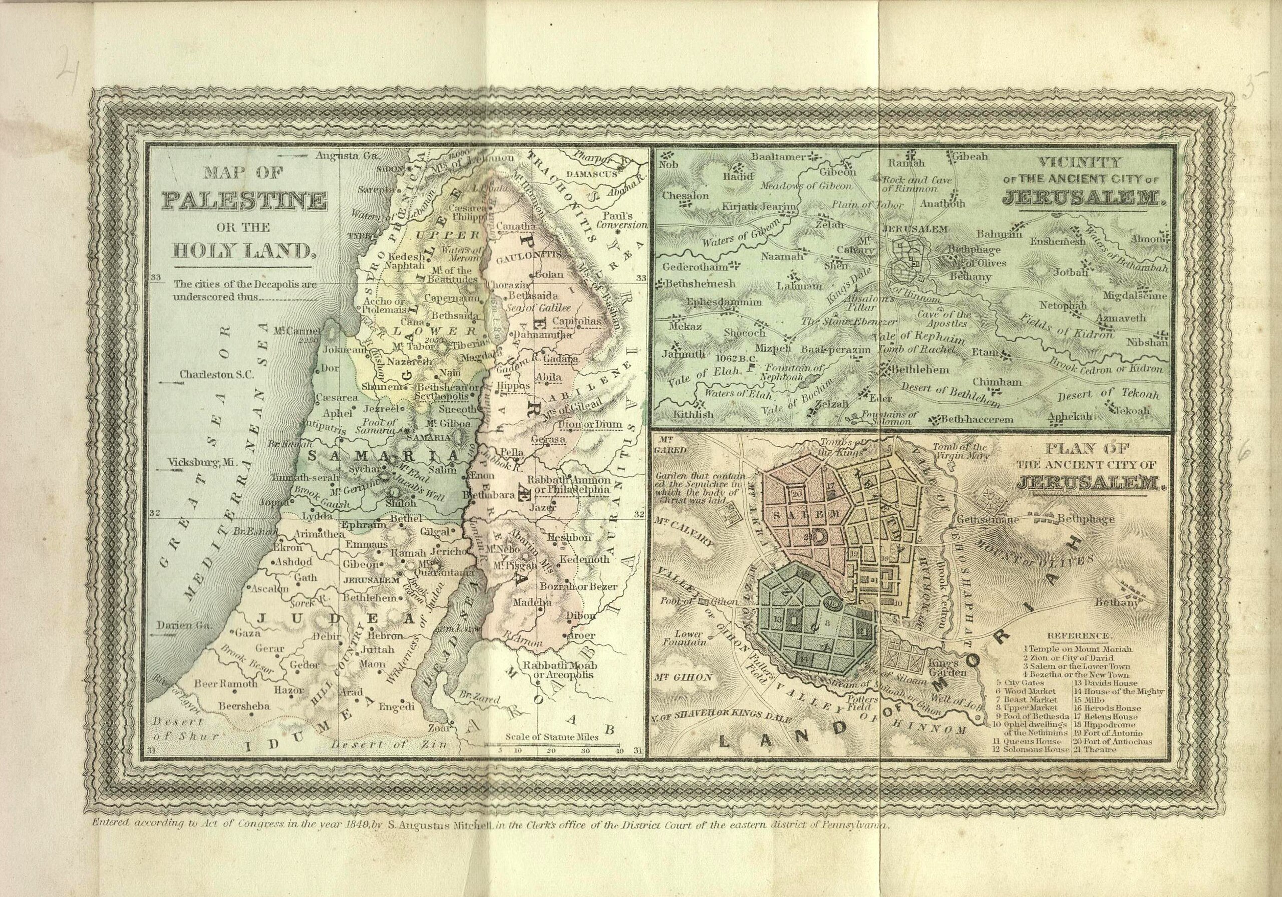
[edit]| Map of Palestine or the Holy Land
( |
||||||||||||||||||||||||
|---|---|---|---|---|---|---|---|---|---|---|---|---|---|---|---|---|---|---|---|---|---|---|---|---|
| Title |
Map of Palestine or the Holy Land |
|||||||||||||||||||||||
| Publisher |
E. H. Butler & Co. |
|||||||||||||||||||||||
| Description |
Map of Palestine or the Holy Land. ... 1849. |
|||||||||||||||||||||||
| Language | English | |||||||||||||||||||||||
| Publication date | 1859 | |||||||||||||||||||||||
| Medium | 1 online resource (1 map). | |||||||||||||||||||||||
| Collection |
|
|||||||||||||||||||||||
| Current location |
|
|||||||||||||||||||||||
| Place of publication | Philadelphia | |||||||||||||||||||||||
| search Merhav catalog | Philadelphia | |||||||||||||||||||||||
| Notes | Digital image of the original in Amir Cahanovitc Collection, Israel. ACC 1102-2.; Digital image received from donor.; From: Mitchell's Biblical and Sabbath School Geography, design for instruction in Sabbath school and Bible classes, 1859.; Inset: Form of the camp of the Israelites.; Three maps on the same sheet. | |||||||||||||||||||||||
| IE PID | IE37128355 | |||||||||||||||||||||||
| Rosetta filename | FL37128357 | |||||||||||||||||||||||
| NNL item ID (P3959) | 990039049020205171 | |||||||||||||||||||||||
| Depicts | Jerusalem – city in the Middle East, holy to the three Abrahamic religions | |||||||||||||||||||||||
| search Merhav catalog | Jerusalem, English | |||||||||||||||||||||||
| search Merhav catalog | E. H. Butler & Co. | |||||||||||||||||||||||
| Source/Photographer |
|
|||||||||||||||||||||||
| Other versions | ||||||||||||||||||||||||
| Jpg / Tif version |
|
|||||||||||||||||||||||

.jpg)

.jpg&action=edit§ion=1)
Licensing
[edit].jpg&action=edit§ion=2)
The copyright situation of this work is theoretically uncertain, because in the country of origin copyright lasts 70 years after the death of the author, and the date of the author's death is unknown. However, the date of creation of the work was over 120 years ago, and it is thus a reasonable assumption that the copyright has expired (see here for the community discussion). Do not use this template if the date of death of the author is known.
| |
| This file has been identified as being free of known restrictions under copyright law, including all related and neighboring rights. | |
File history
Click on a date/time to view the file as it appeared at that time.
| Date/Time | Thumbnail | Dimensions | User | Comment | |
|---|---|---|---|---|---|
| current | 19:03, 1 September 2023 | | 3,195 × 2,238 (4.21 MB) | Geagea (talk | contribs) | pattypan 22.03 |
You cannot overwrite this file.
File usage on Commons
The following page uses this file:
.jpg&oldid=797629606)