File:Map of Nakayama tunnel and surrounding area.svg
Jump to navigation
Jump to search

Size of this PNG preview of this SVG file: 471 × 599 pixels. Other resolutions: 189 × 240 pixels | 377 × 480 pixels | 604 × 768 pixels | 805 × 1,024 pixels | 1,611 × 2,048 pixels | 685 × 871 pixels.
Original file (SVG file, nominally 685 × 871 pixels, file size: 233 KB)
Captions
Captions
Add a one-line explanation of what this file represents
| Description |
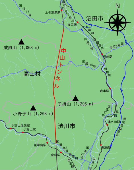
English: Map of Nakayama Tunnel on the Joetsu Shinkansen, roads and rivers nearby 日本語: 上越新幹線中山トンネルと、その周辺の川や道路との位置関係を示す地図 |
| Date | 5 June 2015 |
| Source | Own work |
| Author | Kkairri |
| Permission (Reusing this file) |
This file is licensed under the Creative Commons Attribution-Share Alike 2.0 Generic license.
|
| Other versions | Bitmap ver: Nakayama tunnel map ja.png |
| SVG development |
| Description |
This map was created from OpenStreetMap project data, collected by the community. This map may be incomplete, and may contain errors. Don't rely solely on it for navigation. |
|||
| Date | 5 June 2015, 06:50 (JST) | |||
| Source | openstreetmap.org | |||
| Creator |
OpenStreetMap contributors |
|||
| Permission (Reusing this file) |
OpenStreetMap data is available under the Open Database License (details). Map tiles are licensed under the Creative Commons Attribution-ShareAlike 2.0 license (CC-BY-SA 2.0).
This file is licensed under the Creative Commons Attribution-Share Alike 2.0 Generic license.
|
|||
| Georeferencing | If inappropriate please set warp_status = skip to hide. |
File history
Click on a date/time to view the file as it appeared at that time.
| Date/Time | Thumbnail | Dimensions | User | Comment | |
|---|---|---|---|---|---|
| current | 07:02, 10 June 2015 | | 685 × 871 (233 KB) | 軽快 (talk | contribs) | Fix the typo (口 to 田), lighten boundary line and road line color. |
| 04:04, 8 June 2015 |  | 685 × 871 (233 KB) | 軽快 (talk | contribs) | size down, reflect jawp user's opinion | |
| 08:10, 6 June 2015 |  | 685 × 871 (255 KB) | 軽快 (talk | contribs) | size down, reflect jawp user's opinion | |
| 07:46, 5 June 2015 |  | 685 × 871 (318 KB) | 軽快 (talk | contribs) | {{Information |Description={{en|Map of Nakayama Tunnel on the Joetsu Shinkansen, roads and rivers nearby}}{{ja|上越新幹線中山トンネルと、その周辺の川や道路との位置関係を示す地図}}<!--description are from [[File:Nakayama... |
You cannot overwrite this file.
File usage on Commons
The following 3 pages use this file:
File usage on other wikis
The following other wikis use this file:
- Usage on ja.wikipedia.org