File:Map of Mazatlán, 1981.jpg
Jump to navigation
Jump to search
Size of this preview: 513 × 600 pixels. Other resolutions: 205 × 240 pixels | 411 × 480 pixels | 876 × 1,024 pixels.
Original file (876 × 1,024 pixels, file size: 281 KB, MIME type: image/jpeg)
Captions
Captions
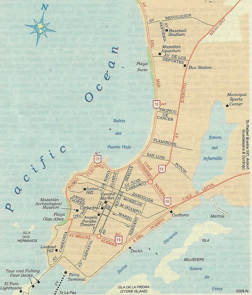
Map of Mazatlán, 1981.
Summary
[edit]
| Description |
English: A short vacation in May, 1981, was spent in Mazatlan and Guadalajara in Western Mexico. This AAA map shows the downtown (centro) area of Mazatlan, as well as the beaches. |
| Date | |
| Source | https://www.flickr.com/photos/nat507/9585270129/ |
| Author | Nathan Hughes Hamilton |
Licensing
[edit]
This file is licensed under the Creative Commons Attribution 2.0 Generic license.
- You are free:
- to share – to copy, distribute and transmit the work
- to remix – to adapt the work
- Under the following conditions:
- attribution – You must give appropriate credit, provide a link to the license, and indicate if changes were made. You may do so in any reasonable manner, but not in any way that suggests the licensor endorses you or your use.
| This image was originally posted to Flickr by nathanh100 at https://flickr.com/photos/41383869@N07/9585270129. It was reviewed on 2 October 2023 by FlickreviewR 2 and was confirmed to be licensed under the terms of the cc-by-2.0. |
File history
Click on a date/time to view the file as it appeared at that time.
| Date/Time | Thumbnail | Dimensions | User | Comment | |
|---|---|---|---|---|---|
| current | 21:53, 2 October 2023 | | 876 × 1,024 (281 KB) | El Nuevo Doge (talk | contribs) | Uploaded a work by Nathan Hughes Hamilton from https://www.flickr.com/photos/nat507/9585270129/ with UploadWizard |
You cannot overwrite this file.
File usage on Commons
There are no pages that use this file.