File:Map of Kent County, Delaware - from actual surveys LOC 2013593082.jpg
Jump to navigation
Jump to search

Size of this preview: 535 × 600 pixels. Other resolutions: 214 × 240 pixels | 428 × 480 pixels | 685 × 768 pixels | 913 × 1,024 pixels | 1,826 × 2,048 pixels | 16,040 × 17,987 pixels.
Original file (16,040 × 17,987 pixels, file size: 35.59 MB, MIME type: image/jpeg)
Captions
Captions
Add a one-line explanation of what this file represents
Summary
[edit]| Warning | The original file is very high-resolution. It might not load properly or could cause your browser to freeze when opened at full size. |
|---|
| Description |
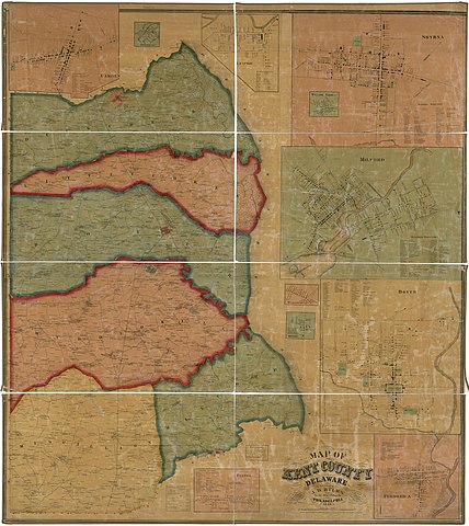
English: General-content county map showing hundreds (townships), rural buildings, and householders' names; the town insets show real-property tracts (lots), building coverage, and owners' names. Hand col. to emphasize hundred boundaries/territories and insets. "Entered according to Act of Congress by J.H. Byles in the year 1859 in the ... Eastern District of Pennsylvania." LC copy imperfect: Brittle, shellacked, cracked, darkened, cloth hemmed at outer edges. Includes statistical table, local business directories, and 11 town/village insets (including Dover, Milford, Smyrna, Camden, Frederica). LC Land ownership maps, 69 Available also through the Library of Congress Web site as a raster image. 2 copies |
||
| Title | Map of Kent County, Delaware : from actual surveys | ||
| Shelf ID | G3833.K4 1859 .F7 G3833.K4 1859 .F7 Copy 2 | ||
| Date | |||
| Source | https://www.loc.gov/item/2013593082/ | ||
| Author | French, J. H. (John Homer); Skinner, J. L.; Byles, A. D.; R.P. Smith'S Map Manufactory; French, J. H. | ||
| Permission (Reusing this file) |
|
||
| Other versions |
|
||
| Location | Milford · Frederica · Delaware · Smyrna · United States · Camden · Kent County · Dover | ||
| Part of | American Memory · Catalog · County Landownership Maps · Geography And Map Division · Cultural Landscapes | ||
| Subject | Cadastral Maps · Milford · Villages · Dover (Del.) · Frederica · Cities And Towns · Delaware · Smyrna · Milford (Del.) · Frederica (Del.) · United States · Maps · Kent County (Del.) · Camden · Smyrna (Del.) · Camden (Del.) · Real Property · Kent County · Landowners · Dover |


Licensing
[edit]
|
This is a faithful photographic reproduction of a two-dimensional, public domain work of art. The work of art itself is in the public domain for the following reason:
The official position taken by the Wikimedia Foundation is that "faithful reproductions of two-dimensional public domain works of art are public domain".
This photographic reproduction is therefore also considered to be in the public domain in the United States. In other jurisdictions, re-use of this content may be restricted; see Reuse of PD-Art photographs for details. | ||||
File history
Click on a date/time to view the file as it appeared at that time.
| Date/Time | Thumbnail | Dimensions | User | Comment | |
|---|---|---|---|---|---|
| current | 09:05, 31 May 2018 | | 16,040 × 17,987 (35.59 MB) | Fæ (talk | contribs) | LOC Maps https://www.loc.gov/item/2013593082/ #713 |
You cannot overwrite this file.
File usage on Commons
The following page uses this file: