File:Map of Iranian Azerbaijan 1945-46 insurgency by Robert Rossow (corrected).svg
Jump to navigation
Jump to search

Size of this PNG preview of this SVG file: 800 × 536 pixels. Other resolutions: 320 × 214 pixels | 640 × 429 pixels | 1,024 × 686 pixels | 1,280 × 857 pixels | 2,560 × 1,714 pixels | 1,498 × 1,003 pixels.
Original file (SVG file, nominally 1,498 × 1,003 pixels, file size: 878 KB)
Captions
Captions
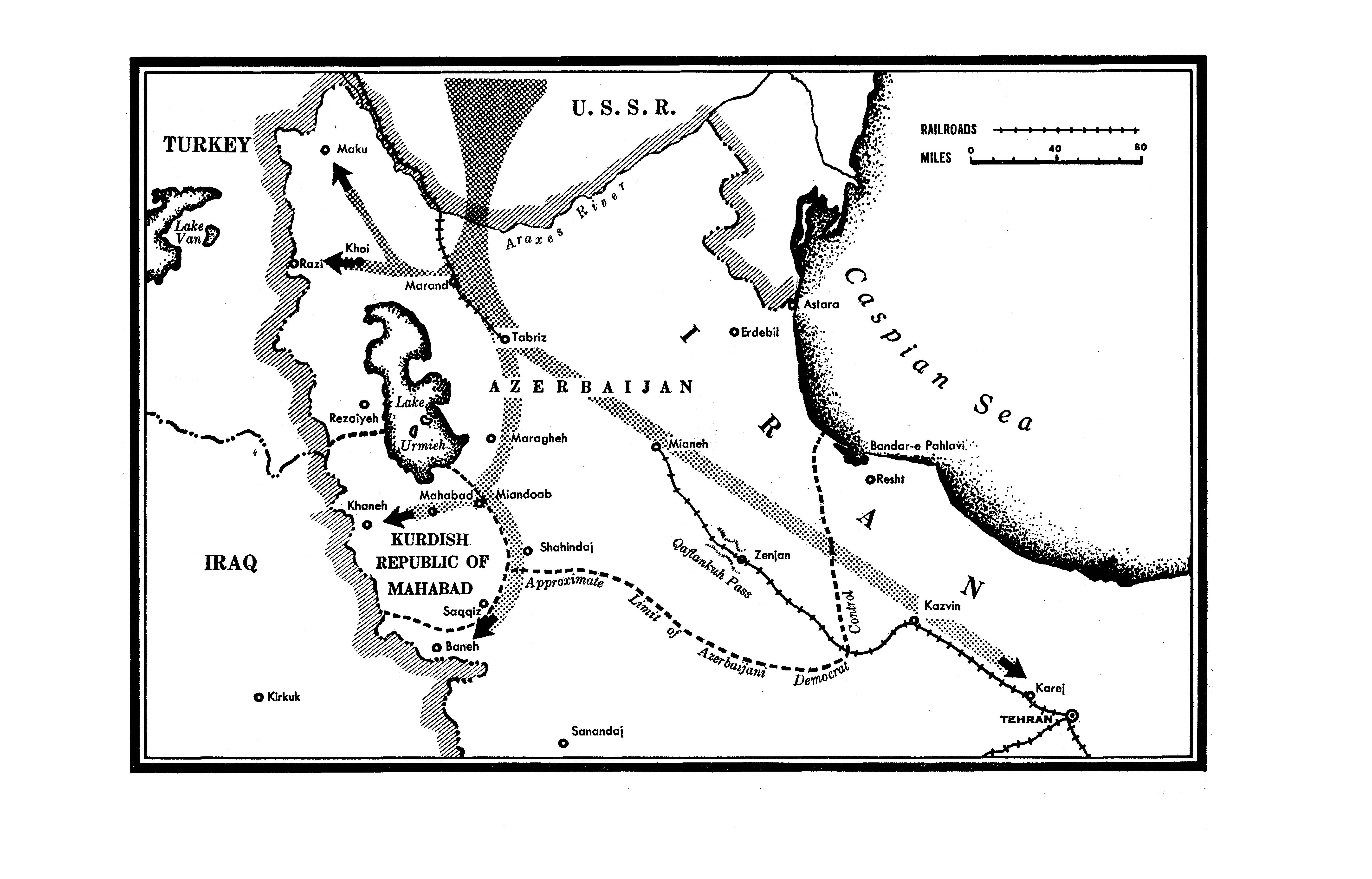
Map of Iranian Azerbaijan during 1945-1946
Summary
[edit]| Description |
English: Map of Iranian Azerbaijan during 1945-1946, when it was occupied by the Red Army and the Soviet puppet states named Republic of Mahabad and People's Government of Azerbaijan. Boundaries are approximate and based on a work by Robert Rossow Jr., an American diplomat stationed in Tabriz.
|
||||||||||||||||||||||||||||||||||||||||||||||||||||||
| Date | |||||||||||||||||||||||||||||||||||||||||||||||||||||||
| Source |
This file was derived from: Map of Iranian Azerbaijan 1945-46 insurgency by Robert Rossow.svg |
||||||||||||||||||||||||||||||||||||||||||||||||||||||
| Author | Derivative work: Golden / Original work: User:Goran tek-en | ||||||||||||||||||||||||||||||||||||||||||||||||||||||
| Permission (Reusing this file) |
This file is licensed under the Creative Commons Attribution-Share Alike 4.0 International license.
|
||||||||||||||||||||||||||||||||||||||||||||||||||||||
| Other versions |
|
||||||||||||||||||||||||||||||||||||||||||||||||||||||
| SVG development | This vector image was created with Inkscape. |
||||||||||||||||||||||||||||||||||||||||||||||||||||||
_-_Near_Saraeyn_-_Iranian_Azerbaijan_-_Iran_(7421215180).jpg)


.svg&action=edit§ion=1)
| Object location | | View this and other nearby images on: OpenStreetMap |
|---|
.svg¶ms=037.800200_N_0046.592900_E_globe:Earth_class:object_type:object_dim:400km_&language=en)
Licensing
[edit].svg&action=edit§ion=2)
I, the copyright holder of this work, hereby publish it under the following license:
This file is licensed under the Creative Commons Attribution-Share Alike 4.0 International license.
- You are free:
- to share – to copy, distribute and transmit the work
- to remix – to adapt the work
- Under the following conditions:
- attribution – You must give appropriate credit, provide a link to the license, and indicate if changes were made. You may do so in any reasonable manner, but not in any way that suggests the licensor endorses you or your use.
- share alike – If you remix, transform, or build upon the material, you must distribute your contributions under the same or compatible license as the original.
File history
Click on a date/time to view the file as it appeared at that time.
| Date/Time | Thumbnail | Dimensions | User | Comment | |
|---|---|---|---|---|---|
| current | 08:30, 16 September 2023 | | 1,498 × 1,003 (878 KB) | Golden (talk | contribs) | Uploaded own work with UploadWizard |
You cannot overwrite this file.
File usage on Commons
There are no pages that use this file.
File usage on other wikis
The following other wikis use this file:
- Usage on fi.wikipedia.org
- Usage on www.wikidata.org
.svg&oldid=802500501)