File:Map of Hamilton County Ohio With Municipal and Township Labels.PNG
Jump to navigation
Jump to search
Size of this preview: 800 × 536 pixels. Other resolutions: 320 × 215 pixels | 640 × 429 pixels | 1,024 × 687 pixels | 1,287 × 863 pixels.
Original file (1,287 × 863 pixels, file size: 136 KB, MIME type: image/png)
Captions
Captions
Add a one-line explanation of what this file represents
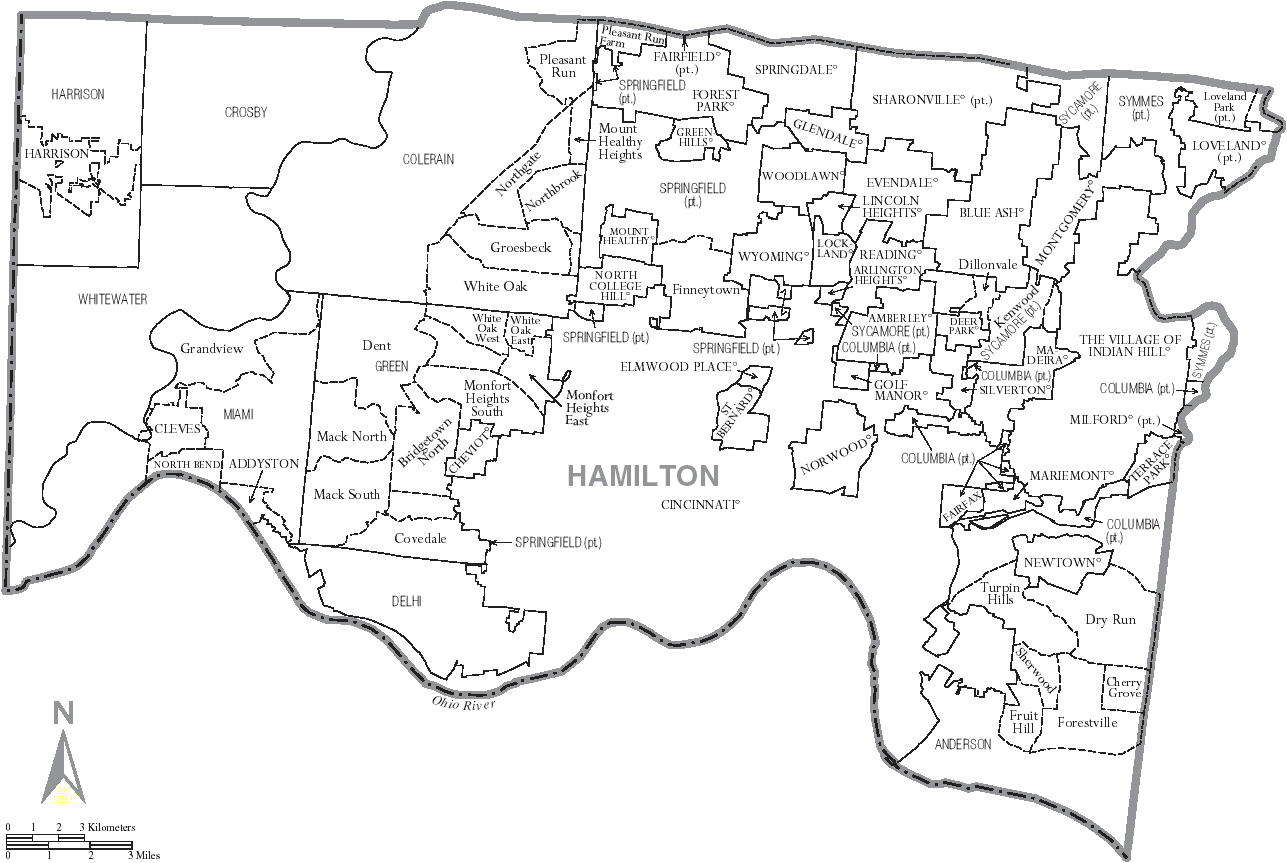
| Description | Map of Hamilton County, Ohio, United States with township and municipal boundaries |
| Date | |
| Source | taken from US Census website [1] and modified by User:Ruhrfisch |
| Author | US Census, Ruhrfisch |
| Permission (Reusing this file) |
US Census / US Government work is public domain, my modifications licensed under the GNU Free Documentation License |

|
Permission is granted to copy, distribute and/or modify this document under the terms of the GNU Free Documentation License, Version 1.2 or any later version published by the Free Software Foundation; with no Invariant Sections, no Front-Cover Texts, and no Back-Cover Texts. A copy of the license is included in the section entitled GNU Free Documentation License. |
| This file is licensed under the Creative Commons Attribution-Share Alike 3.0 Unported license. | ||
| ||
| This licensing tag was added to this file as part of the GFDL licensing update. |
File history
Click on a date/time to view the file as it appeared at that time.
| Date/Time | Thumbnail | Dimensions | User | Comment | |
|---|---|---|---|---|---|
| current | 20:08, 3 July 2006 | | 1,287 × 863 (136 KB) | Ruhrfisch (talk | contribs) | {{Information| |Description= Map of Hamilton County, Ohio, United States with township and municipal boundaries |Source= taken from US Census website [http://www2.census.gov/geo/maps/general_ref/cousub_outline/cen2k_pgsz/oh_cosub.pdf] and modified by [[U |
You cannot overwrite this file.
File usage on Commons
The following 13 pages use this file:
- File:Map of Hamilton County Ohio With Indian Hill Labelled.PNG
- File:Map of Hamilton County Ohio With Wyoming.PNG
- Category:Births in Hamilton County, Ohio
- Category:Deaths in Hamilton County, Ohio
- Category:Education in Hamilton County, Ohio
- Category:Geography of Hamilton County, Ohio
- Category:Hamilton County, Ohio
- Category:Maps of Hamilton County, Ohio
- Category:National Register of Historic Places in Hamilton County, Ohio
- Category:Parks in Hamilton County, Ohio
- Category:People of Hamilton County, Ohio
- Category:Populated places in Hamilton County, Ohio
- Category:Villages in Hamilton County, Ohio
File usage on other wikis
The following other wikis use this file:
- Usage on ar.wikipedia.org
- Usage on arz.wikipedia.org
- Usage on bg.wikipedia.org
- Usage on ceb.wikipedia.org
- Usage on cy.wikipedia.org
- Usage on el.wikipedia.org
- Usage on en.wikipedia.org
- Usage on eu.wikipedia.org
- Usage on glk.wikipedia.org
- Usage on hu.wikipedia.org
- Usage on ja.wikipedia.org
- Usage on mzn.wikipedia.org
- Usage on nl.wikipedia.org
- Usage on pt.wikipedia.org
- Usage on ro.wikipedia.org
- Usage on sr.wikipedia.org
- Usage on ur.wikipedia.org
- Usage on vi.wikipedia.org
- Quận Hamilton, Ohio
- Xã Anderson, Quận Hamilton, Ohio
- Xã Colerain, Quận Hamilton, Ohio
- Xã Columbia, Quận Hamilton, Ohio
- Xã Crosby, Quận Hamilton, Ohio
- Xã Delhi, Quận Hamilton, Ohio
- Xã Green, Quận Hamilton, Ohio
- Xã Harrison, Quận Hamilton, Ohio
- Xã Miami, Quận Hamilton, Ohio
- Xã Springfield, Quận Hamilton, Ohio
- Xã Sycamore, Quận Hamilton, Ohio
- Xã Symmes, Quận Hamilton, Ohio
- Xã Whitewater, Quận Hamilton, Ohio
- Usage on www.wikidata.org