File:Map of Hamilton County, Ohio LOC 2012591123.jpg
Jump to navigation
Jump to search

Size of this preview: 800 × 532 pixels. Other resolutions: 320 × 213 pixels | 640 × 425 pixels | 1,024 × 681 pixels | 1,280 × 851 pixels | 2,560 × 1,702 pixels | 11,210 × 7,451 pixels.
Original file (11,210 × 7,451 pixels, file size: 13.25 MB, MIME type: image/jpeg)
Captions
Captions
Add a one-line explanation of what this file represents
Summary
[edit]| Warning | The original file is very high-resolution. It might not load properly or could cause your browser to freeze when opened at full size. |
|---|
| Description |
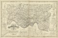
English: "Entered according to and of Congress in the year 1847 William D Emerson in the Clerk's Office of the District Court of Ohio." LC Land ownership maps, 632 Available also through the Library of Congress Web site as a raster image. Includes insets of Sharon, Elizabethtown, Cleves, Mt. Pleasant, Miamitown, Harrison, Springdale, Mt. Auburn, Cummingsville, Newtown, Lockland, Columbia, Reading, Montgomery, Walnut Hills, and Carthage. |
||
| Title | Map of Hamilton County, Ohio | ||
| Shelf ID | G4083.H2G46 1847 .E5 | ||
| Date | |||
| Source | https://www.loc.gov/item/2012591123/ | ||
| Author | Emerson, William D. | ||
| Permission (Reusing this file) |
|
||
| Other versions |
|
||
| Location | United States · Ohio · Hamilton County | ||
| Part of | American Memory · Catalog · County Landownership Maps · Geography And Map Division · Cultural Landscapes | ||
| Subject | Cadastral Maps · Cities And Towns · United States · Maps · Hamilton County · Ohio · Real Property · Landowners |

Licensing
[edit]
|
This is a faithful photographic reproduction of a two-dimensional, public domain work of art. The work of art itself is in the public domain for the following reason:
The official position taken by the Wikimedia Foundation is that "faithful reproductions of two-dimensional public domain works of art are public domain".
This photographic reproduction is therefore also considered to be in the public domain in the United States. In other jurisdictions, re-use of this content may be restricted; see Reuse of PD-Art photographs for details. | ||||
File history
Click on a date/time to view the file as it appeared at that time.
| Date/Time | Thumbnail | Dimensions | User | Comment | |
|---|---|---|---|---|---|
| current | 07:15, 23 May 2018 | | 11,210 × 7,451 (13.25 MB) | Fæ (talk | contribs) | LOC Maps https://www.loc.gov/item/2012591123/ #13631 |
You cannot overwrite this file.
File usage on Commons
The following page uses this file: