File:Map of Eduens people-fr.svg
Jump to navigation
Jump to search

Size of this PNG preview of this SVG file: 577 × 599 pixels. Other resolutions: 231 × 240 pixels | 462 × 480 pixels | 740 × 768 pixels | 986 × 1,024 pixels | 1,972 × 2,048 pixels | 755 × 784 pixels.
Original file (SVG file, nominally 755 × 784 pixels, file size: 75 KB)
Captions
Captions
Add a one-line explanation of what this file represents
| Description |
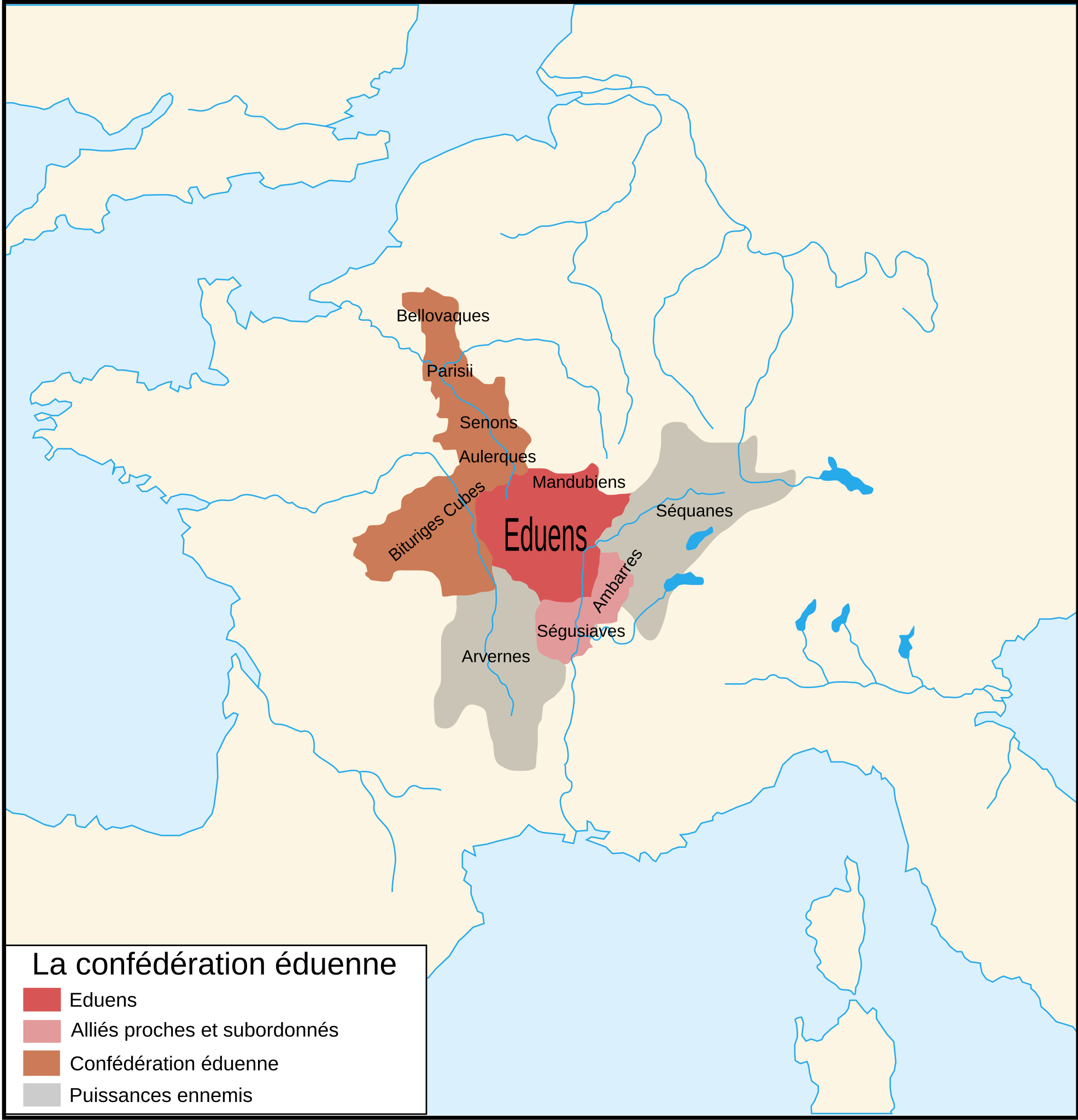
Français : Carte des Eduens English: Territories of the Aedui and allied peoples |
||||||||
| Date | |||||||||
| Source | Image:Éduenscarte.svg by User:Bashar + Image:Blank map of Gaul 1st century BC.svg (Own work)d'apres Christian Goudineau et Christian Peyre, Bibracte et les Éduens, À la découverte d'un peuple gaulois, éditions Errance, 1993 | ||||||||
| Author | historicair 20:02, 7 July 2007 (UTC) | ||||||||
| Permission (Reusing this file) |
I, the copyright holder of this work, hereby publish it under the following licenses:
This file is licensed under the Creative Commons Attribution-Share Alike 2.5 Generic, 2.0 Generic and 1.0 Generic license.
You may select the license of your choice. |
||||||||
| Other versions |
[]
|


|
This SVG file contains embedded text that can be translated into your language, using any capable SVG editor, text editor or the SVG Translate tool. For more information see: About translating SVG files. |
File history
Click on a date/time to view the file as it appeared at that time.
| Date/Time | Thumbnail | Dimensions | User | Comment | |
|---|---|---|---|---|---|
| current | 09:00, 27 April 2008 | | 755 × 784 (75 KB) | Cyberprout (talk | contribs) | {{Information |Description={{fr}}Carte des Eduens {{en}}Maps of Eduens people |Source=Image:Éduenscarte.svg by User:Bashar + Image:Blank map of Gaul 1st century BC.svg (Own work) |Date=07/07/2007 |Author=historicair 20: |
| 20:02, 7 July 2007 |  | 755 × 784 (75 KB) | Historicair (talk | contribs) | {{Information |Description={{fr}}Carte des Eduens {{en}}Maps of Eduens people |Source=Image:Éduenscarte.svg by User:Bashar + Image:Blank map of Gaul 1st century BC.svg (Own work) |Date=07/07/2007 |Author=~~~~ |Permission={{self|GFDL|cc-by-s |
You cannot overwrite this file.
File usage on Commons
The following 16 pages use this file:
.jpg)
File usage on other wikis
The following other wikis use this file:
- Usage on ast.wikipedia.org
- Usage on bg.wikipedia.org
- Usage on br.wikipedia.org
- Usage on ca.wikipedia.org
- Usage on cy.wikipedia.org
- Usage on de.wikipedia.org
- Usage on en.wikipedia.org
- Usage on eo.wikipedia.org
- Usage on es.wikipedia.org
- Usage on eu.wikipedia.org
- Usage on fr.wikipedia.org
- Usage on ja.wikipedia.org
- Usage on ja.wikibooks.org
- Usage on pl.wikipedia.org
- Usage on ro.wikipedia.org
- Usage on ru.wikipedia.org
- Usage on uk.wikipedia.org
- Usage on www.wikidata.org
- Usage on zh.wikipedia.org