File:Map of Coastal Defense WDL9934.png
Jump to navigation
Jump to search
Size of this preview: 800 × 454 pixels. Other resolutions: 320 × 181 pixels | 640 × 363 pixels | 1,024 × 581 pixels | 1,280 × 726 pixels | 1,806 × 1,024 pixels.
Original file (1,806 × 1,024 pixels, file size: 3.72 MB, MIME type: image/png)
Captions
Captions
Add a one-line explanation of what this file represents
Summary
[edit]
| Title |
Русский: Карта береговой обороны
Français : Carte de la défense côtière
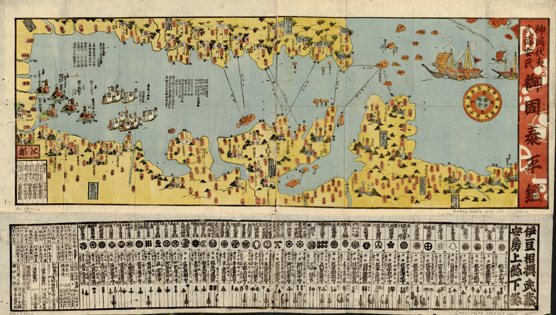
English: Map of Coastal Defense
中文:海防地图
Português: Mapa da defesa costeira
العربية: خريطة الدفاع الساحلي
Español: Mapa de la defensa costera |
| Description |
Русский: В 1853 г. коммодор Военно-морского флота США Мэтью К. Перри вошел в порт Йокогама около Эдо (Токио) с угрожающей эскадрой паровых боевых кораблей. Его цель состояла в том, чтобы открыть Японию для торговли после почти двухвекового ограничения контактов с внешним миром. Визит Перри дал повод сёгунату Эдо и феодальным лордам этих мест пересмотреть способ обороны побережья и начать сооружение укреплений вокруг современного залива Токио. На этой карте okatame (береговой обороны) отмечена система обороны, существовавшая в 1852 г., а также приводится информация о прибывавших с тех пор иностранцах. Сетка координат, вставленная в нижней части карты, содержит наследные гербы и декоративные жезлы самураев (феодалов), отвечавших за оборону прибрежных зон под их административным управлением. Север на карте находится слева внизу, поэтому столица Эдо располагается в левом нижнем углу. Первоначально в планы сёгуната входило построить одиннадцать укреплений, но закончить удалось всего пять. Укрепления и их размеры также указаны в нижнем левом углу, между иностранными флотами и столицей.
Ксилография; Береговая оборона; Побережья; Крепости и фортификационные сооружения; Залив Токио (Япония); Гравюры на дереве Français : En 1853, le commodore Matthew C. Perry de la marine des États-Unis entra dans le port de Yokohama, près d'Edo (Tokyo), avec une flotte impressionnante de navires de guerre à vapeur. Il avait pour mission d'ouvrir les portes commerciales du Japon après presque deux siècles de contact restreint avec le monde extérieur. La visite de Perry incita le shogunat Edo à reconsidérer, avec les seigneurs féodaux de la région, le mode de protection côtière et à ordonner la construction de forts autour de la baie de Tokyo actuelle. Cette carte de l'okatame (défense côtière) représente le système de défense tel qu'il était en 1852 et fournit des informations sur les étrangers arrivés au Japon depuis cette date. Collé au bas de la carte, le tableau quadrillé contient les armoiries héréditaires et les bâtons décoratifs des samouraïs (seigneurs féodaux) responsables de la protection des régions côtières sous leur contrôle administratif. La carte est orientée avec le nord pointant vers le bas à gauche, positionnant la capitale Edo dans l'angle inférieur gauche. À l'origine, le shogunat avait prévu de construire onze forts, mais seuls cinq furent terminés. Les forts et leurs dimensions sont également représentés dans l'angle inférieur gauche, entre les flottes étrangères et la capitale.
Xylographie; Défense côtière; Côtes; Forts et fortifications; Baie de Tokyo (Japon); Gravures sur bois English: In 1853, Commodore Matthew C. Perry of the United States Navy entered the port of Yokohama near Edo (Tokyo) with an intimidating fleet of steam warships. His objective was to open Japan’s doors to trade after nearly two centuries of restricted contact with the outside world. Perry’s visit prompted the Edo shogunate to reconsider, with feudal lords in the area, the method of coastal protection and to order the construction of forts around present-day Tokyo Bay. This okatame (coastal defense) map depicts the system of defense as it was in 1852 and provides information about the foreigners who had since arrived. The gridded chart pasted on the bottom of the map contains the hereditary crests and decorative staffs of the samurai (feudal lords) who were in charge of protecting the coastal areas under their administrative control. The map is oriented with north pointing to the lower left, positioning the capital city of Edo in the lower-left corner. The shogunate initially had planned to build eleven forts but managed to complete only five. The forts and their measurements also are shown on the lower left corner, standing between the foreign fleets and the capital city.
Block printing; Coast defenses; Coasts; Forts and fortifications; Tokyo Bay (Japan); Woodcuts 中文:1853 年,美国海军准将马休·C·佩里 (Matthew C. Perry) 率领着由多艘蒸汽军舰组成的威严舰队驶入江户(东京)附近的横滨港。他的目的是打开日本贸易之门,结束日本已经实施了近两个世纪的锁国外交政策。佩里的到来促使江户幕府与该地区的领主重新考虑海防的方式,并下令在今东京湾附近建设堡垒。这幅 okatame (海防)地图描绘的是 1852 年的防卫系统,并介绍了来到此地的外国人的信息。贴在地图底部的网格图展示了武士(领主)的世袭纹章和装饰物,他们负责保护各自行政控制区域的海岸区。地图的左下方向为北方,首都江户位于左下角。幕府最初计划修建十一座堡垒,但最终只完成五座。堡垒及其度量数据也显示在左下角,位于外国舰队和首都之间。
木版印刷; 海防; 海岸; 堡垒和防御工事; 东京湾(日本); 木刻 Português: Em 1853, o comodoro Matthew C. Perry, da Marinha dos Estados Unidos, entrou no porto de Yokohama, próximo a Edo (Tóquio), com uma frota intimidante de navios de guerra a vapor. Seu objetivo era abrir as portas do Japão para o comércio depois de quase dois séculos de contato restrito com o mundo externo. A visita de Perry levou o xogunato Edo a reconsiderar, com os senhores feudais da região, a forma de proteção costeira, e ordenar a construção de fortes ao redor da atual Baía de Tóquio. Este mapa de okatame (defesa costeira) retrata o sistema de defesa como era em 1852 e fornece informações sobre os estrangeiros que chegaram desde então. O mapa quadriculado colado na parte inferior do mapa contém as insígnias hereditárias e emblemas condecorativos dos samurais (senhores feudais) incumbidos de proteger as regiões costeiras sob seu controle administrativo. O mapa é orientado com o norte apontando para o lado esquerdo inferior, posicionando a cidade capital de Edo no canto inferior esquerdo. O xogunato planejara construir inicialmente 11 fortes, mas conseguiu terminar apenas cinco. Os fortes e suas medidas também são mostrados no canto inferior esquerdo, entre as frotas estrangeiras e a capital.
Impressão xilográfica; Defesas costeiras; Litorais; Fortes e fortificações; Baía de Tóquio (Japão); Xilogravuras العربية: في عام 1853، دخل العميد البحري ماثيو ك. بيري (1794-1858)، من القوات البحرية الأمريكية، إلى ميناء يوكوهاما بالقرب من إيدو (طوكيو) بأسطول مهيب من الباخرات الحربية. وكان هدفه هو إجبار اليابان على الانفتاح بعد قرابة القرنين من العلاقات المحدودة مع العالم الخارجي. دفعت زيارة بيري شوغونية إيدو، والإقطاعيين في المنطقة، لإعادة النظر في طريقة حماية السواحل والأمر ببناء الحصون حول ما يُعرف في الوقت الحاضر باسم خليج طوكيو. تُصور هذه الخريطة نظام دفاع أوكاتام (الدفاع الساحلي) كما كان في عام 1852، كما تُوفر معلومات عن الأجانب الذين توافدوا على المنطقة منذ ذلك الوقت. يحتوي الرسم البياني الشبكي المُلصق أسفل الخريطة على الشارات الموروثة والصولجانات المزخرفة للساموراي (الأمراء الإقطاعيين) والذين كانوا مسؤولين عن حماية المناطق الساحلية التي كانت تحت رقابتهم الإدارية. وُضِعت الخريطة بحيث يكون اتجاه الشمال في أسفل اليسار، وتكون العاصمة إيدو في الركن السفلي الأيسر. خططت الشوغونية في البداية لبناء أحد عشر حصناً ولكنها استطاعت فقط استكمال خمسة منها. تظهر أيضاً الحصون وقياساتها أسفل الركن الأيسر، بين الأساطيل الأجنبية والعاصمة.
طباعة القوالب; الدفاعات الساحلية; السواحل; الحصون والتحصينات; خليج طوكيو (اليابان); الرواسِم الخشبية Español: En 1853, el comodoro Matthew C. Perry, de la armada de los Estados Unidos, entró en el puerto de Yokohama cerca de Edo (Tokio) con una intimidante flota de buques de vapor de guerra. Su objetivo era abrir las puertas de Japón al comercio después de casi dos siglos de contacto limitado con el mundo exterior. La visita de Perry llevó al shogunato Edo a reconsiderar, junto con los señores feudales de la zona, el método de protección de la costa y a ordenar la construcción de fortalezas en torno a la actual bahía de Tokio. Este mapa okatame (de la defensa costera) muestra el sistema de defensa tal como era en 1852, y aporta información sobre los extranjeros que habían llegado. El cuadro cuadriculado pegado en la parte inferior del mapa contiene las crestas hereditarias y los bastones decorativos de los samuráis (señores feudales) que estaban a cargo de la protección de las zonas costeras bajo su control administrativo. El mapa está orientado con el Norte apuntando a la parte inferior izquierda, lo que coloca la ciudad capital de Edo en la esquina inferior izquierda. El shogunato inicialmente había planeado construir once fuertes, pero solo logró completar cinco. En la esquina inferior izquierda también se muestran los fuertes con sus medidas, emplazados entre las flotas extranjeras y la ciudad capital.
Xilografías; Defensas de la costa; Costas; Fuertes y fortificaciones; Bahía de Tokio (Japón); Impresión xilográfica |
| Date | between 1860 and 1869 |
| Medium |
Русский: Карты
Français : Cartes
English: Maps
中文:地图
Português: Mapas
العربية: خرائط
Español: Mapas |
| Dimensions |
English: 1 map : wood block print, color ; 30 x 83 centimeters, folded in covers 17 x 11 centimeters. |
| Collection |
Русский: Библиотека Конгресса
Français : Bibliothèque du Congrès
English: Library of Congress
中文:国会图书馆
Português: Biblioteca do Congresso
العربية: مكتبة الكونغرس
Español: Biblioteca del Congreso |
| Place of creation |
Русский: Токио
Français : Tokyo
English: Tokyo
中文:东京都
Português: Tóquio
العربية: طوكيو
Español: Tokio |
| Notes |
Original language title: 神国伏夷武徳安民 御固泰平鑑 Русский: Масштаб не выдержан.
Français : La carte n'est pas dessinée à l'échelle.
English: Not drawn to scale.
中文:无比例尺。
Português: Não está desenhado em escala.
العربية: ليست مرسومة حسب المقياس.
Español: No está dibujado a escala. |
| References | http://hdl.loc.gov/loc.wdl/dlc.9934 |
| Source/Photographer |
|
Licensing
[edit]
|
This is a faithful photographic reproduction of a two-dimensional, public domain work of art. The work of art itself is in the public domain for the following reason:
The official position taken by the Wikimedia Foundation is that "faithful reproductions of two-dimensional public domain works of art are public domain".
This photographic reproduction is therefore also considered to be in the public domain in the United States. In other jurisdictions, re-use of this content may be restricted; see Reuse of PD-Art photographs for details. | ||||
File history
Click on a date/time to view the file as it appeared at that time.
| Date/Time | Thumbnail | Dimensions | User | Comment | |
|---|---|---|---|---|---|
| current | 05:34, 12 March 2014 | | 1,806 × 1,024 (3.72 MB) | Fæ (talk | contribs) | =={{int:filedesc}}== {{Artwork |artist = |author = |title ={{ru|1=Карта береговой обороны}} {{fr|1=Carte de la défense côtière}} {{en|1=Map of Coastal Defense}} {{zh|1=海防地图}} {{pt|1=Mapa da defesa costeira}} {{ar|1=خر... |
You cannot overwrite this file.
File usage on Commons
The following page uses this file: