File:Map of Cathedral Peak Granodiorite.svg

Original file (SVG file, nominally 743 × 696 pixels, file size: 346 KB)
Captions
Captions
|
Summary
[edit]
| Description |
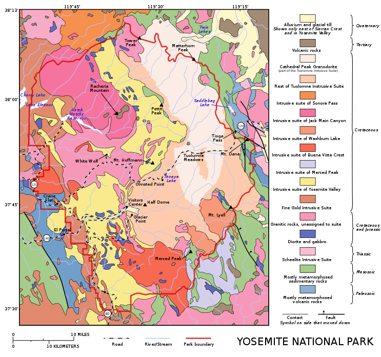
Map of Yosemite National Park based on a map by the USGS image from here (archive). Original notes that the data was "generalized from geological map of Yosemite National Park and vicinity (Huber and others, in press)" and that "an intrusive suite is a grouping of genetically related plutonic rocks". Cathedral Peak Granodiorite area added from this file of the USGS. Cathedral Peak Granodiorite is shown in purple. |
| Date | (UTC) |
| Source |
This file was derived from: Map of Yosemite National Park.svg: |
| Author |
|
Licensing
[edit]
- You are free:
- to share – to copy, distribute and transmit the work
- to remix – to adapt the work
- Under the following conditions:
- attribution – You must give appropriate credit, provide a link to the license, and indicate if changes were made. You may do so in any reasonable manner, but not in any way that suggests the licensor endorses you or your use.
- share alike – If you remix, transform, or build upon the material, you must distribute your contributions under the same or compatible license as the original.
Original upload log
[edit]
This image is a derivative work of the following images:
- File:Map_of_Yosemite_National_Park.svg licensed with Cc-by-sa-3.0
- 2012-05-25T22:07:03Z Grandiose 746x646 (320892 Bytes) Hopefully restore rivers
- 2012-05-23T21:25:08Z Grandiose 746x646 (1328592 Bytes) == {{int:filedesc}} == {{Information |Description=uploaded from : http://en.wikipedia.org/wiki/Image:General_geologic_map_of_Yosemite_area.png Other version: [[:File:Cathedral Peak Granodiorit.png]] PD USGS image from http:
Uploaded with derivativeFX
File history
Click on a date/time to view the file as it appeared at that time.
| Date/Time | Thumbnail | Dimensions | User | Comment | |
|---|---|---|---|---|---|
| current | 09:23, 18 June 2012 | | 743 × 696 (346 KB) | Grandiose (talk | contribs) | Move YNP label; fix TIS border in SE. |
| 21:35, 16 June 2012 |  | 743 × 696 (347 KB) | Grandiose (talk | contribs) | Saddlebag lake v3, colours. | |
| 11:14, 4 June 2012 |  | 743 × 696 (347 KB) | Grandiose (talk | contribs) | Fix colours | |
| 08:47, 4 June 2012 |  | 743 × 696 (347 KB) | Grandiose (talk | contribs) | Make faults thicker in key | |
| 19:55, 31 May 2012 |  | 743 × 696 (347 KB) | Grandiose (talk | contribs) | Fix rogue colour, move "Park" | |
| 19:43, 31 May 2012 |  | 743 × 696 (347 KB) | Grandiose (talk | contribs) | Tone down colours; extend key; new road look; fix borders/edging; other fixes | |
| 21:26, 28 May 2012 |  | 746 × 646 (329 KB) | Grandiose (talk | contribs) | == {{int:filedesc}} == {{Information |Description=Map of Yosemite National Park based on a map by the USGS image from [http://geology.wr.usgs.gov/docs/usgsnps/yos/yosmap.html here]. Original notes that the da... |
You cannot overwrite this file.
File usage on Commons
There are no pages that use this file.
File usage on other wikis
The following other wikis use this file:
- Usage on en.wikipedia.org
- Wikipedia:WikiProject Protected areas
- Portal:Geology
- Wikipedia:Featured pictures/Diagrams, drawings, and maps/Maps
- User:Grandiose
- Cathedral Peak Granodiorite
- Talk:Cathedral Peak Granodiorite
- User:Grandiose/articles
- Wikipedia:Featured pictures thumbs/31
- Wikipedia:WikiProject Geology/Recognized content
- User:Grandiose/archive5
- Wikipedia:Featured picture candidates/Cathedral Peak Granodiorite
- Wikipedia:Featured picture candidates/June-2012
- Wikipedia:Featured picture candidates/Cathedral Peak Granodiorite (2)
- User:Grandiose/archive8
- Wikipedia:Wikipedia Signpost/2012-11-05/Op-ed
- Wikipedia:Wikipedia Signpost/Single/2012-11-05
- Wikipedia:Picture of the day/October 2013
- Template:POTD/2013-10-18
- Wikipedia:Main Page history/2013 October 18
- Wikipedia:WikiProject Geology/Automated list of recognized content
- Half Dome Granodiorite
- El Capitan Granite
- Kuna Crest Granodiorite
- Portal:Geography/Selected picture
- Wikipedia:WikiProject Mountains/Recognized content
- Portal:Geology/Selected picture
- Geological maps of Yosemite National Park
- English-language SVG maps
- Intrusive Suites
- Granodiorite in California
- Cathedral Peak
- Cathedral Peak Granodiorite
- Quaternary alluvium in California
- Quaternary glacial till in California
- Paleogene volcanic rocks in California
- Neogene volcanic rocks in California
- Tuolumne Intrusive Suite
- Intrusive Suite of Sonora Pass
- Intrusive Suite of Jack Main Canyon
- Intrusive Suite of Washburn Lake
- Intrusive Suite of Buena Vista Crest
- Intrusive Suite of Merced Peak
- Intrusive Suite of Yosemite Valley
- Fine Gold Intrusive Suite
- Cretaceous granitic rocks unassigned to suites
- Jurassic granitic rocks unassigned to suites
- Cretaceous diorite in California
- Jurassic diorite in California
- Scheelite Intrusive Suite
- Mesozoic sedimentary rocks in California
- Mesozoic metamorphic rocks in California
- Paleozoic volcanic rocks in California
- Paleozoic metamorphic rocks in California
- Mesozoic metasedimentary rocks in California
- Paleozoic metavolcanic rocks in California