File:Map of California.jpg
Jump to navigation
Jump to search

Size of this preview: 800 × 510 pixels. Other resolutions: 320 × 204 pixels | 640 × 408 pixels | 1,024 × 652 pixels | 1,280 × 815 pixels | 2,560 × 1,630 pixels | 4,514 × 2,875 pixels.
Original file (4,514 × 2,875 pixels, file size: 752 KB, MIME type: image/jpeg)
Captions
Captions
Add a one-line explanation of what this file represents
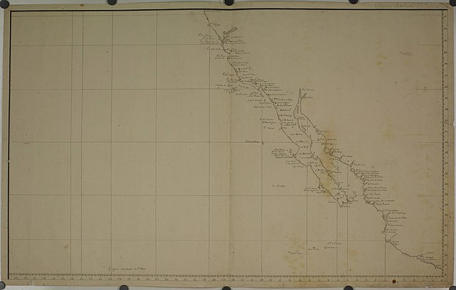
| Map of California
( |
||||||||||||||||||
|---|---|---|---|---|---|---|---|---|---|---|---|---|---|---|---|---|---|---|
| Artist |
Unknown author |
|||||||||||||||||
| Title |
Map of California |
|||||||||||||||||
| Description |
MS, 93.5 x 58. A very fine manuscript map extending from 16° to 41° N and from 06° East of San Blas to 39 3/4 ° W. The map, however, is blank west of about 21° The date assigned to it is about as approximate as can be given, being calculated from the mission of Santa Cruz shown on it, which was founded in February, 1793. Those founded later are not shown. Although very correct in some respects, it contains some glaring errors. The map is chiefly remarkable for being in all probability the earliest one known to show the alignment of the channel islands as San Miguel, Santa Rosa, and Santa Cruz. On the Bodega map of 1792 and the Martínez y Zayas map of 1793 the alignment is still the old one of San Bernardo, San Miguel, and Santa Cruz. Vancouver in his account of the islands mentions two different maps with the above systems of names and adopted the one shown on this map. It is clear therefore that the change must have been made about this time on some Spanish map which he saw and which he adopted for some unknown reason. It seems impossible that the change was made deliberately; at least ten general maps of this coast had been produced since 1770 all reading San Bernardo, San Miguel, and Santa Cruz, so that if any nomenclature was fixed, this was. There are a few additional names not found on previous maps. Cabo Mendocino is in 40°. |
|||||||||||||||||
| Depicted place | Northern California | |||||||||||||||||
| Date | circa 1794 | |||||||||||||||||
| Medium | Map | |||||||||||||||||
| Dimensions | Original map, 96.5 x 61 cm | |||||||||||||||||
| Collection |
|
|||||||||||||||||
| Current location |
Maps and Mapping at The Claremont Colleges Henry Raup Wagner Collection of Maps and Atlases, folder w825 |
|||||||||||||||||
| Source/Photographer | http://ccdl.libraries.claremont.edu/cdm/ref/collection/p15831coll14/id/51 | |||||||||||||||||
| Permission (Reusing this file) |
|
|||||||||||||||||


File history
Click on a date/time to view the file as it appeared at that time.
| Date/Time | Thumbnail | Dimensions | User | Comment | |
|---|---|---|---|---|---|
| current | 05:24, 2 January 2019 | | 4,514 × 2,875 (752 KB) | Missvain (talk | contribs) | User created page with UploadWizard |
You cannot overwrite this file.
File usage on Commons
The following page uses this file: