File:Map of Bushveldt Carbineers in northern Transvaal.png
Jump to navigation
Jump to search

Size of this preview: 800 × 533 pixels. Other resolutions: 320 × 213 pixels | 640 × 426 pixels | 1,043 × 695 pixels.
Original file (1,043 × 695 pixels, file size: 125 KB, MIME type: image/png)
Captions
Captions
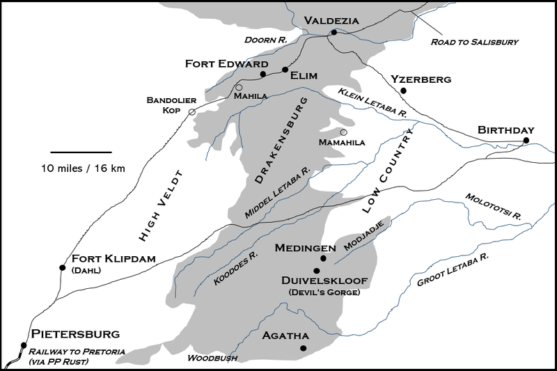
Area of operations of the Bushveldt Carbineers, northern Transvaal, 1901
Summary
[edit]
| Description |
English: Map to assist in understanding the operations of the Bushveldt Carbineers, including Breaker Morant, in 1901-02. The map is primarily based upon the 1893 Jeppe Map of the Zoutpansberg Goldfields, South Africa. Near Fort Edward are Cooksley's farm, Lovedale Park, Sweetwaters farm (Bristow's) and Rossbach (Schiel). |
| Date | |
| Source | Own work |
| Author | MonDiTriQuad |
| Camera location | | View this and other nearby images on: OpenStreetMap |
|---|
Licensing
[edit]
I, the copyright holder of this work, hereby publish it under the following license:
This file is licensed under the Creative Commons Attribution-Share Alike 4.0 International license.
- You are free:
- to share – to copy, distribute and transmit the work
- to remix – to adapt the work
- Under the following conditions:
- attribution – You must give appropriate credit, provide a link to the license, and indicate if changes were made. You may do so in any reasonable manner, but not in any way that suggests the licensor endorses you or your use.
- share alike – If you remix, transform, or build upon the material, you must distribute your contributions under the same or compatible license as the original.
File history
Click on a date/time to view the file as it appeared at that time.
| Date/Time | Thumbnail | Dimensions | User | Comment | |
|---|---|---|---|---|---|
| current | 13:23, 27 April 2022 | | 1,043 × 695 (125 KB) | MonDiTriQuad (talk | contribs) | Uploaded own work with UploadWizard |
You cannot overwrite this file.
File usage on Commons
There are no pages that use this file.
File usage on other wikis
The following other wikis use this file:
- Usage on en.wikipedia.org