File:Map of Botkyrka with roads and urban areas.svg
Jump to navigation
Jump to search

Size of this PNG preview of this SVG file: 487 × 599 pixels. Other resolutions: 195 × 240 pixels | 390 × 480 pixels | 624 × 768 pixels | 832 × 1,024 pixels | 1,665 × 2,048 pixels | 630 × 775 pixels.
Original file (SVG file, nominally 630 × 775 pixels, file size: 30 KB)
Captions
Captions
Add a one-line explanation of what this file represents
| Description |
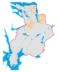
Svenska: Karta över Botkyrka kommun med tätorter, vägar och större vattenansamlingar English: Map of Botkyrka Municipality with urban areas, roads and water bodies |
||||||||
| Date | 12-05-2007 | ||||||||
| Source | self-made - used the Swedish Election Board map as base. | ||||||||
| Author | Strangnet | ||||||||
| Permission (Reusing this file) |
I, the copyright holder of this work, hereby publish it under the following licenses:
This file is licensed under the Creative Commons Attribution-Share Alike 2.5 Generic, 2.0 Generic and 1.0 Generic license.
You may select the license of your choice. |

File history
Click on a date/time to view the file as it appeared at that time.
| Date/Time | Thumbnail | Dimensions | User | Comment | |
|---|---|---|---|---|---|
| current | 10:58, 17 May 2007 | | 630 × 775 (30 KB) | Strangnet (talk | contribs) | {{Information |Description={{sv|Karta över Botkyrka kommun med tätorter, vägar och större vattenansamlingar}}<br /> {{en|Map of Botkyrka Municipality with urban areas, roads and water bodies}} |Sou |
| 22:51, 11 May 2007 |  | 903 × 734 (29 KB) | Strangnet (talk | contribs) | {{Information |Description={{sv|Karta över Botkyrka kommun med tätorter, vägar och större vattenansamlingar}}<br /> {{en|Map of Botkyrka Municipality with urban areas, roads and water bodies}} |Sou | |
| 22:48, 11 May 2007 |  | 903 × 734 (177 KB) | Strangnet (talk | contribs) | {{Information |Description={{sv|Karta över Botkyrka kommun med tätorter, vägar och större vattenansamlingar}}<br /> {{en|Map of Botkyrka Municipality with urban areas, roads and water bodies}} |Sou |
You cannot overwrite this file.
File usage on Commons
There are no pages that use this file.
File usage on other wikis
The following other wikis use this file:
- Usage on sv.wikipedia.org