File:Map of Bennington County, Vermont LOC 2011590005.jpg
Jump to navigation
Jump to search

Size of this preview: 778 × 600 pixels. Other resolutions: 311 × 240 pixels | 623 × 480 pixels | 996 × 768 pixels | 1,280 × 987 pixels | 2,560 × 1,973 pixels | 16,679 × 12,857 pixels.
Original file (16,679 × 12,857 pixels, file size: 35.6 MB, MIME type: image/jpeg)
Captions
Captions
Add a one-line explanation of what this file represents
Summary
[edit]| Warning | The original file is very high-resolution. It might not load properly or could cause your browser to freeze when opened at full size. |
|---|
| Description |
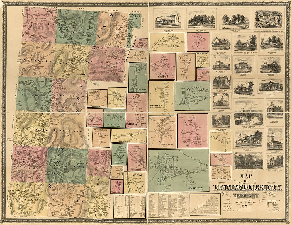
English: Relief shown by hachures. Shows landownership. Includes: 29 insets; 21 illustrations; Statistics table; Business directories; and Table of distances. "Entered according to Act of Congress, A.D. 1856 by H.F. Walling in the District Clerks office of the Southern District of New York." "C.B. Peckham at H.F. Walling's New York Map Store, No. 90 Fulton St." Available also through the Library of Congress Web site as a raster image. Cut and mounted on cloth. LC Land ownership maps, 1183 |
||
| Title | Map of Bennington County, Vermont | ||
| Shelf ID | G3753.B4 1856 .R5 G3753.B4 1856 .R5 | ||
| Date | |||
| Source | https://www.loc.gov/item/2011590005/ | ||
| Author | Rice, E.; Harwood, C. E. | ||
| Permission (Reusing this file) |
|
||
| Other versions |
|
||
| Location | United States · Vermont · Bennington County | ||
| Part of | American Memory · Catalog · County Landownership Maps · Geography And Map Division · Cultural Landscapes | ||
| Subject | Bennington County (Vt.) · Maps · Vermont · Bennington County · United States |


Licensing
[edit]
|
This is a faithful photographic reproduction of a two-dimensional, public domain work of art. The work of art itself is in the public domain for the following reason:
The official position taken by the Wikimedia Foundation is that "faithful reproductions of two-dimensional public domain works of art are public domain".
This photographic reproduction is therefore also considered to be in the public domain in the United States. In other jurisdictions, re-use of this content may be restricted; see Reuse of PD-Art photographs for details. | ||||
File history
Click on a date/time to view the file as it appeared at that time.
| Date/Time | Thumbnail | Dimensions | User | Comment | |
|---|---|---|---|---|---|
| current | 03:52, 12 June 2018 | | 16,679 × 12,857 (35.6 MB) | Fæ (talk | contribs) | LOC Maps https://www.loc.gov/item/2011590005/ #27576 |
You cannot overwrite this file.
File usage on Commons
The following page uses this file: