File:Map of Assyria-es.svg
Jump to navigation
Jump to search

Size of this PNG preview of this SVG file: 800 × 550 pixels. Other resolutions: 320 × 220 pixels | 640 × 440 pixels | 1,024 × 704 pixels | 1,280 × 880 pixels | 2,560 × 1,759 pixels | 2,145 × 1,474 pixels.
Original file (SVG file, nominally 2,145 × 1,474 pixels, file size: 531 KB)
Captions
Captions
Add a one-line explanation of what this file represents
Summary
[edit]| Description |
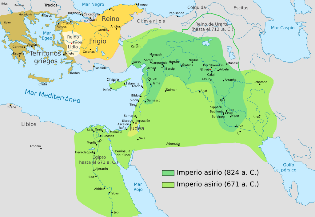
[] English: Map of the Assyrian Empire Español: Extensión del Imperio Asirio Polski: Mapa Asyrii w 824 i 671 r. p.n.e. Português: Extensão do Império Assírio العربية : خارطة الإمبراطوريَّة الآشوريَّة. فارسی : نقشه امپراتوری آشور |
| Date | |
| Source |
This file was derived from: Map of Assyria-pt.svg : Renato de carvalho ferreira |
| Author |
|
| Other versions |
[]
|


Licensing
[edit]
I, the copyright holder of this work, hereby publish it under the following license:
This file is licensed under the Creative Commons Attribution-Share Alike 4.0 International license.
- You are free:
- to share – to copy, distribute and transmit the work
- to remix – to adapt the work
- Under the following conditions:
- attribution – You must give appropriate credit, provide a link to the license, and indicate if changes were made. You may do so in any reasonable manner, but not in any way that suggests the licensor endorses you or your use.
- share alike – If you remix, transform, or build upon the material, you must distribute your contributions under the same or compatible license as the original.
File history
Click on a date/time to view the file as it appeared at that time.
| Date/Time | Thumbnail | Dimensions | User | Comment | |
|---|---|---|---|---|---|
| current | 10:09, 15 April 2020 | | 2,145 × 1,474 (531 KB) | Pzgulyas (talk | contribs) | File uploaded using svgtranslate tool (https://tools.wmflabs.org/svgtranslate/). Added translation for hu. |
| 22:30, 9 December 2018 |  | 2,145 × 1,474 (539 KB) | Rowanwindwhistler (talk | contribs) | Improved version | |
| 07:23, 14 July 2016 |  | 2,145 × 1,474 (84 KB) | Rowanwindwhistler (talk | contribs) | https://en.wikipedia.org/wiki/Wikipedia:WikiProject_Maps/Conventions | |
| 09:14, 9 October 2014 |  | 2,145 × 1,474 (78 KB) | Rowanwindwhistler (talk | contribs) | User created page with UploadWizard |
You cannot overwrite this file.
File usage on Commons
The following 9 pages use this file:
File usage on other wikis
The following other wikis use this file:
- Usage on es.wikipedia.org
- Usage on eu.wikipedia.org