File:Map of Allier Department (France) with NumberedElectoralDistrictsAndCantons2015.png
Jump to navigation
Jump to search

Size of this preview: 800 × 586 pixels. Other resolutions: 320 × 234 pixels | 640 × 468 pixels | 1,000 × 732 pixels.
Original file (1,000 × 732 pixels, file size: 67 KB, MIME type: image/png)
Captions
Captions
Add a one-line explanation of what this file represents
Summary
[edit]_with_NumberedElectoralDistrictsAndCantons2015.png&action=edit§ion=1)
| Description |
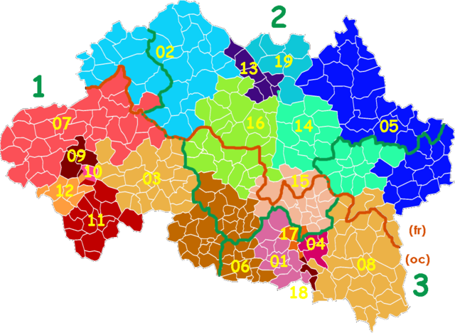
Occitan : Carta del departament d'Alèir amb las circonscripcions legislativas, los cantons e las comunas en 2015 |
| Date | |
| Source | Own work |
| Author | Jfblanc |
Licensing
[edit]_with_NumberedElectoralDistrictsAndCantons2015.png&action=edit§ion=2)
I, the copyright holder of this work, hereby publish it under the following license:
This file is licensed under the Creative Commons Attribution-Share Alike 4.0 International license.
- You are free:
- to share – to copy, distribute and transmit the work
- to remix – to adapt the work
- Under the following conditions:
- attribution – You must give appropriate credit, provide a link to the license, and indicate if changes were made. You may do so in any reasonable manner, but not in any way that suggests the licensor endorses you or your use.
- share alike – If you remix, transform, or build upon the material, you must distribute your contributions under the same or compatible license as the original.
File history
Click on a date/time to view the file as it appeared at that time.
| Date/Time | Thumbnail | Dimensions | User | Comment | |
|---|---|---|---|---|---|
| current | 20:50, 1 November 2014 | | 1,000 × 732 (67 KB) | Jfblanc (talk | contribs) | Green: Number of Electoral District for French National Assembly Yellow: Number of Canton for 2015 Departemental Election oc/fr: Occitan-French lingustic boundary |
| 20:34, 1 November 2014 |  | 1,000 × 732 (271 KB) | Jfblanc (talk | contribs) | User created page with UploadWizard |
You cannot overwrite this file.
File usage on Commons
There are no pages that use this file.
File usage on other wikis
The following other wikis use this file:
- Usage on nl.wikipedia.org
- Usage on oc.wikipedia.org
_with_NumberedElectoralDistrictsAndCantons2015.png&oldid=708353510)