File:Map of Allegany Co., N.Y. - from actual surveys LOC 2013593215.jpg
Jump to navigation
Jump to search

Size of this preview: 558 × 599 pixels. Other resolutions: 223 × 240 pixels | 447 × 480 pixels | 715 × 768 pixels | 953 × 1,024 pixels | 1,906 × 2,048 pixels | 16,168 × 17,368 pixels.
Original file (16,168 × 17,368 pixels, file size: 50.91 MB, MIME type: image/jpeg)
Captions
Captions
Add a one-line explanation of what this file represents
Summary
[edit]| Warning | The original file is very high-resolution. It might not load properly or could cause your browser to freeze when opened at full size. |
|---|
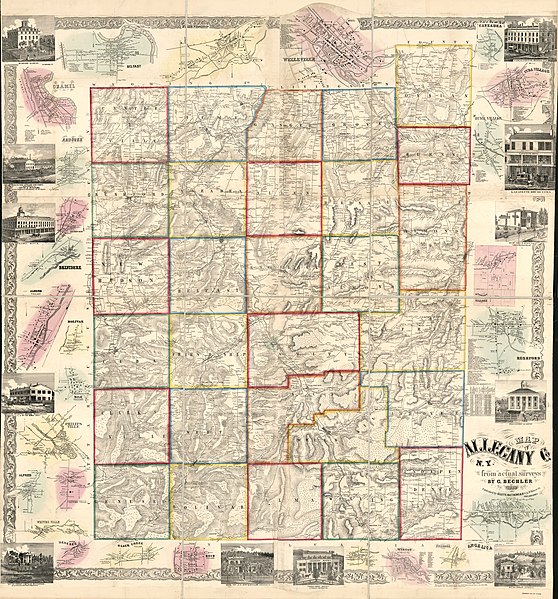
| Description |
English: General-content county map showing rural buildings and householders' names. Relief shown by hachures. LC copy hand colored to emphasize town (township) boundaries and areas of village/city insets. "Entered according to act of Congress in the year 1856 by Robert Pearsall Smith in the ... Eastern District of Pennsylvania." LC copy imperfect: Trimmed on all outer edges, sectioned to 6 panels to enable folding. LC Land ownership maps, 474 Includes county statistical table, local business directories (some indexed), 26 small-town/village insets (including Wellsville), and illustrations of prominent buildings. Available also through the Library of Congress Web site as a raster image. 2 copies |
||
| Title | Map of Allegany Co., N.Y. : from actual surveys | ||
| Shelf ID | G3803.A5 1856 .B4 G3803.A5 1856 .B4 Copy 2 | ||
| Date | |||
| Source | https://www.loc.gov/item/2013593215/ | ||
| Author | Bechler, Gustavus R.; Smith, Robert Pearsall; Gillette, Matthews & Co. | ||
| Permission (Reusing this file) |
|
||
| Location | United States · New York · Allegany County · New York (State) · Wellsville | ||
| Part of | American Memory · Catalog · County Landownership Maps · Geography And Map Division · Cultural Landscapes | ||
| Subject | Allegany County (N.Y.) · Wellsville (N.Y.) · Cities And Towns · Allegany County · Villages · United States · Maps · New York (State) · Landowners |

Licensing
[edit]
|
This is a faithful photographic reproduction of a two-dimensional, public domain work of art. The work of art itself is in the public domain for the following reason:
The official position taken by the Wikimedia Foundation is that "faithful reproductions of two-dimensional public domain works of art are public domain".
This photographic reproduction is therefore also considered to be in the public domain in the United States. In other jurisdictions, re-use of this content may be restricted; see Reuse of PD-Art photographs for details. | ||||
File history
Click on a date/time to view the file as it appeared at that time.
| Date/Time | Thumbnail | Dimensions | User | Comment | |
|---|---|---|---|---|---|
| current | 04:38, 30 May 2018 | | 16,168 × 17,368 (50.91 MB) | Fæ (talk | contribs) | LOC Maps https://www.loc.gov/item/2013593215/ #15409 |
You cannot overwrite this file.
File usage on Commons
There are no pages that use this file.