File:Map of African phonology-Afrikaans.svg
Jump to navigation
Jump to search

Size of this PNG preview of this SVG file: 635 × 600 pixels. Other resolutions: 254 × 240 pixels | 508 × 480 pixels | 813 × 768 pixels | 1,084 × 1,024 pixels | 2,169 × 2,048 pixels | 1,525 × 1,440 pixels.
Original file (SVG file, nominally 1,525 × 1,440 pixels, file size: 721 KB)
Captions
Captions
Add a one-line explanation of what this file represents
Summary
[edit]
| Description |
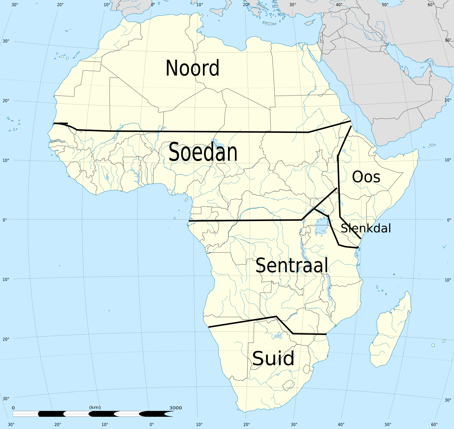
English: Blank administrative map of political Africa as in 2011-07, for geo-location purposes. On English Wikipedia, in "Template:Location_map_Africa" to set marker along curved latitude/longitude lines. Français : Carte administrative vierge de l'Afrique politique telle qu'en 07/2011, destinée à la géolocalisation. En Wikipédia Francais, a la Modèle:Géolocalisation/Afrique pour carte avec marqueur-image. A Lambert azimuthal equal-area projection, WGS84 datum *Standard meridian: 15°E *Standard parallel: 0° Scale: 1:23,420,000 (precision: 5,855 km) |
| Date | (UTC) |
| Source |
This file was derived from: Africa location map.svg: |
| Author |
|
| This is a retouched picture, which means that it has been digitally altered from its original version. Modifications: Add phonological regions in Afrikaans. The original can be viewed here: Africa location map.svg:
|
Licensing
[edit]
I, the copyright holder of this work, hereby publish it under the following licenses:
This file is licensed under the Creative Commons Attribution-Share Alike 3.0 Unported license.
- You are free:
- to share – to copy, distribute and transmit the work
- to remix – to adapt the work
- Under the following conditions:
- attribution – You must give appropriate credit, provide a link to the license, and indicate if changes were made. You may do so in any reasonable manner, but not in any way that suggests the licensor endorses you or your use.
- share alike – If you remix, transform, or build upon the material, you must distribute your contributions under the same or compatible license as the original.

|
Permission is granted to copy, distribute and/or modify this document under the terms of the GNU Free Documentation License, Version 1.2 or any later version published by the Free Software Foundation; with no Invariant Sections, no Front-Cover Texts, and no Back-Cover Texts. A copy of the license is included in the section entitled GNU Free Documentation License. |
You may select the license of your choice.
Original upload log
[edit]
This image is a derivative work of the following images:
- File:Africa_location_map.svg licensed with Cc-by-sa-3.0, GFDL
- 2011-07-14T19:13:55Z Sting 1525x1440 (792744 Bytes) Sudan/South Sudan 2011-07 border update
- 2010-07-02T20:12:15Z Sting 1525x1440 (586394 Bytes) == {{int:filedesc}} == {{Location|00|00|00|N|15|00|00|E|scale:30000000}} {{Information |Description={{en|Blank administrative map of political [[:en:Africa|Africa]], for geo-location purposes.}} {{fr|Carte administrative vier
Uploaded with derivativeFX
Licensing
[edit]
I, the copyright holder of this work, hereby publish it under the following license:
This file is licensed under the Creative Commons Attribution-Share Alike 3.0 Unported license.
- You are free:
- to share – to copy, distribute and transmit the work
- to remix – to adapt the work
- Under the following conditions:
- attribution – You must give appropriate credit, provide a link to the license, and indicate if changes were made. You may do so in any reasonable manner, but not in any way that suggests the licensor endorses you or your use.
- share alike – If you remix, transform, or build upon the material, you must distribute your contributions under the same or compatible license as the original.
File history
Click on a date/time to view the file as it appeared at that time.
| Date/Time | Thumbnail | Dimensions | User | Comment | |
|---|---|---|---|---|---|
| current | 00:20, 8 May 2012 | | 1,525 × 1,440 (721 KB) | Jcwf (talk | contribs) | == {{int:filedesc}} == {{Information |Description={{en|Blank administrative map of political Africa as in 2011-07, for geo-location purposes. On English Wikipedia, in "Template:Location_map_Africa" to... |
You cannot overwrite this file.
File usage on Commons
There are no pages that use this file.
File usage on other wikis
The following other wikis use this file:
- Usage on af.wikipedia.org